
Journal of Social Sciences and Humanities, Vol. 1, No. 4, September 2015 Publish Date: Jul. 4, 2015 Pages: 354-360
Utility of Inselbergs and Boulders as Rock-Shelter Monasteries: A Geoarchaeological Study of Sigiriya and Its Environs
Jinadasa Katupotha1, *, Kusumsiri Kodituwakku2
1Departmentof Geography, University of Sri Jayewardenepura, Nugegoda, Sri Lanka
2Sigiriya Museum, Central Cultural Funds, Sigiriya, Sri Lanka
Abstract
Inselbergs and other rock outcrops such as erratic boulders, granitic tors and corestones formed natural rock-shelters, and are important in archaeological studies. These rock-shelters extensively used to prevent weather afflictions, and later converted as living places by prehistoric man and the members of different faiths in the historical period. They left behind debris, tools and other artifacts, which mark the footsteps of the civilization of humankind. By 5,000 yr BP civilized Yakka, Naga and Deva natives who lived as natives in Sri Lanka have built separate sequestered settlements, and used rock shelters. Large numbers of such natural rock shelters are found in Sigiriya and its environs. The natives, who used these rock shelters consecrated them to Buddhist monks. These were widely used as monasteries during the Early Anuradhapura Period, especially between 2,300 yr BP and 1,800 yr BP. Field observations of seven locations in the area reveal that the architects selected big holes and fractures of the main rock outcrops or a shelter of a single boulder or clusters of boulders to construct comfortable monasteries. These age-old monasteries have geoarcheological values, which reveal our buried cultures.
Keywords
Rock-Shelters, Sigiriya and Its Environs, Natives, Buddhist Monasteries, Early Anuradhapura Period, Geoarchaeology
Received: June 18, 2015
Accepted: June 20, 2015
Published online: July 3, 2015
@ 2015 The Authors. Published by American Institute of Science. This Open Access article is under the CC BY-NC license. http://creativecommons.org/licenses/by-nc/4.0/
1. Introduction
A rock-shelter is a shallow cave-like opening at the base of a bluff or cliff. An overhanging projection of a rock that could provide shelter from the elements; often a rich source of archaeological evidence, because they were occupied by humans belonging to different cultures over many centuries [10]. In Sri Lanka, inclined inselberg or inclined granitic gneiss rocky boulders were formed as rock shelters. Such structures appear as minor feature caves, but many of them are important archaeological or historical sites. Rock-shelters have distributed throughout the world with archaeological value. These features were reported from Mumba Rock Shelter, Northern Tanzania [5], Meadowcroft Rock-shelter in Pennsylvania [1], southwestern France [10], southern Namaqualand, South Africa [15], Sibudu rock-shelter KwaZulu-Natal province, South Africa [7], rock-shelters of Bhimbetka in India [2], Franchthi Cave in Greece [9], Swat-Malakand Area in Pakistan [13], Tam Hang Rock-shelter in Northern Laos [8], Djadjiling Rock-shelter in Western Australia [4] and many from other parts of the world. All these descried emphasizing rock-shelter dwellers, deposits, paintings as well as monasteries.
Rock-shelters are typically wider than caves and they extend to deep and have an overhang. They can develop in limestone, as in southwestern France, or in clastic rocks as in much of the southeastern United States of America. In many places such as southwestern France, they are produced by differential weathering of the bedrock, in which weaker (generally fine-grained sediments, e.g. shales) are weathered more intensely than harder strata [10]. In Sri Lanka, rock-shelters have been developed in metamorphosed granitic gneiss rocks. In the fluvial environment, they can be produced by streams undercutting cliff edges, and in coastal areas, wave-cut niches are also well known. Because rock shelters provided natural shades from the weather, prehistoric humans often used these rock shelters as living-places, to keep local food resources and left behind debris, tools, and other artifacts.
In Sri Lanka, except inselbergs, three types of rocky boulders similar to (a) erratic boulders, (b) granitic tors and (c) corestones are significant geologic structures, which formed rock shelters. The term 'erratic' is commonly used to refer to blocks or masses of rocks, ranging in size from pebbles to large boulder rocks (hundreds of thousands of metric tons in weight). Granite tors are freestanding rock outcrops that rise abruptly from the surrounding smooth and gentle slopes of rounded hill summits or ridge crests. Corestones are boulders occurring individually or in piles at the ground surface, or in exposed sections. They are rounded or are broadly rectangular joint blocks of granite formed as a result of subsurface weathering in a manner similar to a tor but entirely separated from the bedrock surrounded by saprolite. Such large round rocks may account for the substantial number of "pre-rounded" glacial erratic boulders. Similar rock hills, knobs, ridges or small mountains are left as erosional remnants because of their more resistant rock composition [6], but many steep-sided and erosional remnants like boulder formations, which formed rock shelters, can be correlated with paleoclimatic changes [13].
During the periods between middle Paleolithic (300,000 - 50,000 yr BP) and upper Paleolithic (50,000 - 10,000 yr BP) times, prehistoric humans in Sri Lanka, extensively used rock shelters. Effluxion of time, civilized Yakkaa, Naaga and Devaa, who lived as native people by early Holocene to middle Holocene had built settlements in the country all in a tumble; they also used rock shelters. Sigiriya is a relict inselberg type rock outcrop, and other rock outcrops of its environs have steep-sided and boulder formations. These boulder formations are laid on the flat terrain to undulating terrain, and rolling and hilly terrain. Such a landform is situated on the Second Planated Surface (Figure 3), which rises above MSL (mean sea level) to 480m altitude [13]. A large number of rock-shelters are found in Sigiriya Boulder Garden [3] and its environs, and the natives have offered these to Buddhist monks. Later, these structures were widely converted as monasteries during the Early Anuradhapura Period, especially between 2,300 yr BP and 1,800 yr BP. Field investigations of seven locations in the area have helped to identify the bearing of the boulders and their usage.
2. Methodology
The field investigations were conducted in seven locations of rock shelter monasteries in the study area. In this paper, information regarding the size and dimensions of boulders was gathered between July and October 2014 from localities within the Sigiriya and its environs (Table 1). It reveals that the constructors, who built rock-shelter monasteries, selected big holes and fractures of the main rock outcrops and a shelter of a single boulder or clusters of boulders. Due to the time constraint, limited fieldworks were done to identify the geological diversity of rock shelters. Likewise, the condition of the ceilings of rock shelters, which were resistant to erosion and weathering were also examined. It is obvious that a softer stratum formed from feldspars and mica that was subject to greater erosion and weathering, and these contained common minerals of the gneiss rocks. During the rainy season water seeps down, forcing it along the cracks and accelerating and influencing the weathering conditions. Similarly, excreta of the mega and mesofauna, and also account for the deterioration of rock-shelters. Besides, readings taken in situ, for the latitude and the longitude using GPS (GARMIN Etrex) were compared with Google readings for accuracy.
Table 1. Number of Rock-shelters in each site at Sigiriya and its surroundings.
| Name of the Site | No. of Rock-shelters | GPS Location | Dimensions | |
| Large shelter | Small shelter | |||
| Sigiriya BG | 30 | 7°57'25"N 80°45'30"E | L=9.0m, H=8.5m | L=4.2m, H=3.0m |
| Pidurangala | 14 | 7°58'11"N 80°45'39"E | L=90.0m, H=5.0m | L=4.0m, H=3.0m |
| Magallena | 03 | 7°58'30"N 80°43'16"E | L=39.5m, H=5.0m | L=11.0m H=2.1m |
| Nagolla (Batakanda) | 08 | 7o58'03" N 80o43'10"E | L=5.5m, H=5.0m | L=3.5m, H=3.0m |
| Enderagala | 10 | 7°54'32"N 80°45'12"E | L=6.0m, H=5.0m | L=4.5m, H=3.2m |
| Pothana | 10 | 7°57'50"N 80°44'31"E | L=12.0m, H 7.3m | L=4.3m, H=4.0m |
| Nagaslena | 02 | 7°56'32"N 80°45'28"E | L=5.0m, H=3.5m | L=2.5m, H=1.5m |
L= Length, H=Height.Source: Field observation, 2014
3. Geographical Setting of the Study Area
Sigiriya rock outcrop site, was declared a UNESCO World Heritage Site since 1982. From the third century BCE, Buddhist monks occupied Sigiriya, but it is said that it was only after King Kasyapa seizing the throne in 1527 yr BP, the palace and gardens were built and the rock fortified. The Sigiriya is located in Inamalu Korale in Dambulla Divisional Secretariat Division (Figure 1). Although, the Sigiriya rocky mass is situated rising about 364m above MSL, on the Second Planated Surface, the surrounding area stretches in an undulating terrain with heights between 100m and 150m. Rock-shelters created by erratic boulders, granite tors and corestones are also located in the same Planated Surface. The local drainage pattern shows the dendritic drainage pattern, with small streams flowing into the southeast, north and the northwest.
Reddish Brown Earth and Low Humic Glay soils extend due to local erosion and weathering in the area. Distribution of annual rainfall varies between 1,250 and 1,500 mm, and the maximum rainfall occurs from October to December. Based on the local geology, relief and climatic conditions the prominent vegetation types are the dry monsoonal forest and the tropical thorny forest. However, tropical inselbergs are hot spots for plant and animal biodiversity, due to the high turnover of species between sites, and the presence of organisms almost restricted to the rock shelter habitats with isolated patches of vascular vegetation surrounded by bare rock or cryptogamic vegetation [17]. The main rock type of the area contains undifferentiated tectonically intercalated metasediment and metaigneus. Such rocks consist of quartz, potash feldspar, acid plagioclase, and biotite mica. The granite-gneiss is sometimes used to denote macrocrystalline gneisses that are rich in granitic material and recognized as granite gneiss [12, Figure 2].
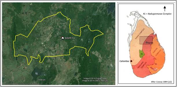
Figure 1. Location of the Inamaluwa Korale, where Sigiriya inslburg is situated (Image courtesy, Google Earth).
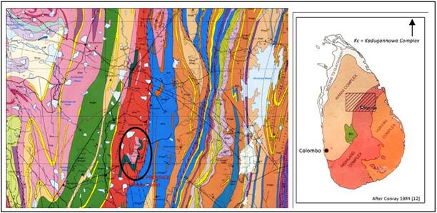
Figure 2. Geological map of Sigiriya area. ![]() = Sigiriya rock site, Blue colour = Marble, usually coarse grained and dolomite, locally high calcite marble present; Orange colour = Pegmatitic granatoid gneiss [12].
= Sigiriya rock site, Blue colour = Marble, usually coarse grained and dolomite, locally high calcite marble present; Orange colour = Pegmatitic granatoid gneiss [12].
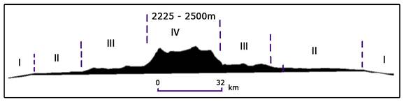
Figure 3. Diagrammatic section across Sri Lanka from west to east showing the four planated surfaces. I – first (submerged), II– second (Flat terrain to Undulating terrain, Rolling and Hilly Terrains, III - third (Dissected Rolling and Hilly; Steeply Dissected Rolling and Hilly Terrains, and lV - fourth (Mountainous and Rugged Central Highland), [modified by 13].
Similarly, granite gneiss appears as migmatite gneiss, and it is a rock, which is a mixture of metamorphic rock and igneous rock. Geologically, inseburgs, erratics, granitic tors, and corestones are made by these types. Nevertheless, limestone veins and quartz veins are distributed in the area, but such rock types were not used as rock-shelters.
4. Results and Discussion
The inselburgs or monadnocks are sometimes designated as bornhardts and boulder inselbergs (Kopjes). Wind and water attack the original surface leaving round-topped inselbergs. However, inselburgs and other boulders at Sigiriya and its environs described above are mainly formed by Highland and Wanni Complexes of rock types [6], and scatted throughout the 2nd and 3rdPlanated Surfaces (Figure 3).
Geologically, the inselbergs, erratic boulders and other rock outcrops in Sri Lanka can be classified as high-grade metamorphic rocks of granitoid origin of the Highland Complex, which is the largest unit and forms the backbone of the Precambrian rocks in Sri Lanka. The texture of these rocks shows that they have been formed from coarse grains. Many boulders of the sites have faced different directions during their moving and clustering due to retreating of huge ice sheets and fluvio-glacial action created by the melting of glaciers after the Karoo Glaciation (360–260 Ma).
Many inselbergs, granite tors and corestones are naturally found as turtle-back shaped and big dome-shaped rocks, and formed as rock shelters due to formation processes and weathering conditions. Cooray [6] interprets that throughout the length and breadth of the lowest peneplain (presently designate as Second Planated Surface), rise like lone sentinels, as a number of scattered steep-sided rock hills and knobs such as Sigiriya, Yapahuwa, and Gunner's Quoin (Dimbulagala). They are often archaeologically important and have become famous in Sri Lanka's history as sites of fortresses, palaces and temples. Even today, nearly all the more prominent rock hills are the site of ancient and modern shrine and temples; these constitute one of the most striking elements of the cultural landscape of the country.

Photographs A & B. (A) = Broken rock blocks have formed as shelter at Nagaslena area, and (B) = A rock shelter has formed from huge boulders at Pidurangala.
The archaeological evidence from caves within the inselbergs and rock shelters fashioned by erratic boulders, granite tors or cluster of corestones indicate that they had been used by palaeolithic people as their homes and as gathering places, dating from 700,000 yr BP to 3,000 yr BP. By 5,000 yr BP civilized Yakkas, Nagas and Devas who lived as native people have built settlements in the country all in a tumble, and have also used rock shelters. A large number of rock shelters formed of huge boulders are found in Sigiriya and its environs. These have been offered to Buddhist monks by the native people.


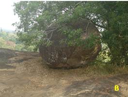
Photographs C & D. A huge rock-shelter at Pidurangala. It is about 90m long and 5-6m high. First half of the rock-shelter = C, and second half of the rock-shelter = D. Reclined Lord Buddha’s Image (12.15m long and this image is about 1,100 years old.) is inside of the shelter.


Boulder rock-shelters at Pidurangala (E & F) area. These shelters have valued as ancient monasteries and palaeolithic sites. Such valued many rock-shelters have been destroyed by newly constructed structures.
Rock-shelters in the study area show geological diversity, because of the mineral content and their distribution pattern during the metamorphism process. These can be identified as pegmatitic granatoid gneiss, which created by devolatilisation (dewatering) of metamorphic rock. In some places, the boulders and other outcrops are migmatite. Migmatite is a mixture of metamorphic rock and igneous rock. It is created when a metamorphic rock such as gneiss partially melts and then that melt recrystallizes into an igneous rock, creating a mixture of the unmelted metamorphic part with the recrystallized igneous part [12]. The field evidence of seven locations in the study area reveals that the constructors, who built rock-shelter monasteries, have selected the big holes and fractures of the main rock outcrops. The boulders at Nagaslena are on the inselberg, and broken blocks have formed as a shelter (Photograph A). Pidurangala areas are of migmatite and a shelter of a single boulder or shelters of clusters (boulders) used to construct the monasteries (Photographs A – F).


Boulder rock-shelters at Pidurangala (G) and Enderagala (H) areas. These shelters have valued as ancient monasteries and Palaeolithic sites and. Such valued rock-shelters have been damaged by newly constructed structures. These structures act as major barriers for deep excavations.
There was a custom of constructing small stupas on the top of inselbergs, and these stupas would be a symbol depicting the difficulty of reaching the inselbergs. Therefore inselbergs and erratic boulders were very useful as natural structures for constructing rock-shelter monasteries in all planated surfaces of Sri Lanka. Noticed all rock shelters which have values the archaeological, geoarcheological and as the significance of Palaeolithic sites, have been exploited and destroyed by many footloose groups, (Photographs C – I).
Field investigations further revealed that the main minerals of the gneiss rocks, particularly feldspar, mica, garnet and hornblende were eroded and weathered by wind and wet climatic conditions during the past million years. The condition of the ceilings of rock-shelters was also damaged by the flaking process. It is obvious that during the rainy seasons seeping force along the cracks also accelerated multiple flaking, splintering and back weathering due to loss of undefinable stone aggregates. Microbiological colonization to dark-colored crust tracing the rock surface; exfoliation; granular disintegration into/grus (grus is an accumulation of angular, coarse-grained fragments of sand and gravel resulting from the granular disintegration by the processes of chemical weathering and mechanical weathering of crystalline rocks). Similarly, excreta of the mega fauna (wild boars, wild cattle including baffaloes, wild cats and other animals) and mesofauna (different kinds of reptiles), and also account for the deterioration of rock-shelters.


Photographs I & J. Rock-shelters have been formed by huge boulders at lower area of the Sigiriya inselburg. The area designates as Boulder Garden (BG) [3]. Such shelters also have valued as palaeolithic sites and ancient monasteries, but these have destroyed of late due to constructing unplanned structures as well.
By the Early Anuradhapura Period, most of these rock shelters had been converted to monasteries and used exclusively by Buddhists monks. Such usage continued between 2,300 yr B.P. and 1,800 yr B.P. Drip ledges (kataram) were a salient feature of all rock-shelter monasteries, and they produced these to stop the water dripping inside the rock shelters (Photographs A – G). All locations reveal that the architects who touched up the rock shelter monasteries made them more comfortable and safer. Accordingly, these monasteries have geo-archeological values, which can be used to reveal our buried cultures and their evolution. Table 1 shows the number of rock shelters at Sigiriya and its environs. These have been either partially destroyed due to construction work or are facing danger of being destroyed by treasure thieves (Photographs H & I) or local power groups and politicians.


Photographs H & I. A rock shelter monastery at Kitulhitiya area. This shelter has palaeolihic, archaeological and geoarchaeological values. A statue of Lord Buddha in this shelter made by crystalline limestone has smashed by treasure thieves.
5. Conclusion
Inselbergs like Sigiriya and other rocky boulders such as erratic boulders, granatic tors and corestones in Sigiriya and its environs have extensively been used by prehistoric humans to to protect themselves from weather, safe and utilized as living-places, and later by Yakka, Naga and Deva tribes. These native people offered rock shelter for Buddhist monks, and these structures appeared as monasteries during the Early Anuradhapura Period, especially between 2,300 yr BP and 1,800 yr BP. During this usage, they left behind debris, tools and other artefacts, but the archaeologically invaluable monument type rock outcrops are either partially destroyed due to construction work or facing danger of being destroyed. Therefore, it is highly required to conserve these places as natural heritages because of their archaeological, historical and scenic values.
Acknowledgments
Our profound thanks go to Professor S.B. Hettiarachchi, former Vice-Chancellor, University of Sri Jayewardenepura, former Director, Abhayagiri Vihara Project and former Sri Lankan Ambassador, France for comments and suggestions. Thanks extended for Professor Gamini Adhikari, Former Director General, Central Cultural Fund (CCF), Colombo 7, Mr. Chandana Weerasena (Project Manager, Sigiriya Project, CCF). Thanks are also due to Ms. Navoda Gunarathna (Record Indexing Officer - J.R. Jayewardene Centre Museum, Colombo 7) for her help on this manuscript.
References
- Adovasio J., Gunn J.D., Donahue J. and Stuckenrath R.1975.Excavations at Meadowcroft Rock Shelter, 1973-1974: A Progress Report. Pennsylvania Archaeologist 45(3), pp.1-30.
- Archaeological Survey of India (2003). Rock Shelters of Bhimbetka, Continuity through Antiquity, Art & Environment. A proposal for nomination for inclusion in the World Heritage List.
- Bandaranayake, Senaka. 1993. Sigiriya. The Central Cultural Triangle. UNESCO/CCF Publication, Colombo, Sri Lanka. pp112-135.
- Boone W. Law, Cropper N. Dawnand Petchey Fiona (2010).Djadjiling Rockshelter: 35,000 14C Years of AboriginalOccupation in the Pilbara, Western Australia, Short Reports, Aurtalian Archaeology 70, 68-69.
- Brauer, Gunter I (1980) Human Skeletal Remains From Mumba Rock Shelter, Northern Tanzania. American Journal of Physical Anthropology 52:71-84 (1980).
- Cooray, P.G. (1984). An Introduction to the Geology of Sri Lanka (2nd Edition), National Museum of Sri Lanka Publication, Colombo.
- Daily NewsThu, Dec 08, (2011).Rock Shelter Inhabitants Slept in Comfort 77,000 Years Ago.Excavations in a South African rock shelter uncover prehistoric bedding, opening an additional window on early modern human behavior.
- Demeter Fabrice, Sayavongkhamdy Thongsa, Patole-Edoumba Elise, Coupey Anne-Sophie et al. 2010. Tam Hang Rockshelter: Preliminary Study of a Prehistoric Site in Northern Laos. Asian Perspectives, Vol. 48, No. 2 The University of Hawai‘i Press. 291-308 pp.
- Farrand R. William (2001). Sediments and Stratigraphy in Rockshelters and Caves: A Personal Perspective on Principles and Pragmatics.Geoarchaeology: An International Journal, Vol. 16, No. 5, 537– 557.
- Goldberg Paul and Macphail I. Richard (2006). Practical and Theoretical Geoarchaeology.2006 by Blackwell Science Ltd, a Blackwell Publishing company. 169-187 pp.
- Goldberg Paul and Rolfe D Mandel. (2008). Caves and Rockshelters. Encyclopedia of Archaeology, ed. by Deborah M. Pearsall. © 2008, Academic Press, New York. 966-974 pp.
- GSMB. (1995). Sri Lanka 1:100,000 Geology (Provisional Map Series, Anuradhapura – Polonnaruwa, Sheet 8).
- Katupotha, J. (2013). Palaeoclimate change during Glacial Periods: Evidence from Sri Lanka. Journal of Tropical Forestry and Environment Vol. 3, No. 01 (2013) 42-54.
- Olivieri Luca Maria (2010).Painted Rock Shelters of the Swat-Malakand Area From Bronze Age to Buddhism.Submitted for obtaining the doctoral degree at the Department of History and Cultural Studies, Freie Universität Berlin, In November 2010,
- Orton Jayson, Klein G Richard, Mackay Alex, Schwortz Steve and Steele E Teresa (2011). Two Holocene rock shelter deposits from the Knersvlakte, southern Namaqualand, South Africa. September 2011 KwaZulu-Natal Museum Southern African Humanities 23: 109–150.
- Perspective on Principles and Pragmatics.Geoarchaeology: An International Journal, Vol. 16, No. 5, 537–557 (2001).
- Porembskij. S., Szarnnski P. Mundj, and Barthloït, W.(1992). Ecological conditions and floristic diversity of an inselberg in the savanna zone of Ivory Coast Mt Niangbo. Actes du colloque international de Phytogéographie tropicale. Paris, juin 1993, 251-261.


