
Journal of Social Sciences and Humanities, Vol. 1, No. 4, September 2015 Publish Date: Jun. 17, 2015 Pages: 288-296
A First Approach to Navigation and Trade on the West - Pontic Coast, from Its Beginnings to the Roman Antiquity
Romeo Boşneagu1, *, Valentina Voinea2, Ana Ion3
1Geography Department, Tomis University, Constanta, Romania
2National History and Archaeology Museum, Constanta, Romania
3Foreign Languages Department, "Mircea cel Bătrân" Naval Academy, Constanta, Romania
Abstract
Navigation in the Black Sea finds its beginnings as far back as prehistory. The early navigation on the West Pontic coast is related to the development of the Thracian and the Geto-Dacian civilizations, and also, to the Greek colonization. The history of navigation in these places begins with the Istros, known since the time of the Egyptians. The western Black Sea coast area was part of the freight traffic system of the Greco-Roman world. The goods arriving by sea in the Balkan peninsula provinces were then distributed on the navigable rivers. The importance of Tomis, for the Roman trade in the Black Sea, is illustrated by the large number of epigraphic attestations of merchants and sailors existing in the metropolis. In the Roman-Byzantine period, in the province of Scythia Minor (at the time, the West Pontic coast belonged to this roman province), numerous naval and maritime units were concentrated, along with ground troops.
Keywords
Navigation,West Pontic Coast, Antiquity, Ship
Received:April 9, 2015
Accepted: May 10, 2015
Published online: June 14, 2015
@ 2015 The Authors. Published by American Institute of Science. This Open Access article is under the CC BY-NC license. http://creativecommons.org/licenses/by-nc/4.0/
1. Introduction
Transport of goods and people by sea has a long history. It appeared together with the human need to move on water, to know what lies beyond the horizon, being intertwined with the history of shipbuilding. For centuries these two activities have come to interact with each other.
The evolution of human society required, among others, the development of navigation, and sea transport, and also, the differentiation of vessels into several categories, i.e. smaller and faster ships, war ships, trade and transportation ships etc. For all these purposes ships had to become heavier and larger, with bigger storage capacities, and with better propulsion means, i.e. oars or sails (Boşneagu, 2004).
Starting with the Eneolithic period the history of human communities within the Istro-Pontic area witnessed alternating periods of flourishing and decay. Archaeological discoveries in the West Pontic area reveal vestiges of prehistoric maritime traditions, including the existence of harbours, long before the Greek colonization (Brătianu, 1988).
The first floating crafts used by the Paleolithic people were the rafts made of tree trunks. Later, during the Mesolithic, with the improvement of work tools, the monoxila boat was manufactured, by digging out a hollowed tree trunk. It was a simple water craft which, as ethnographic examples show, was used up until the 20th century (Marinescu et. all. 2001).
2. Prehistoric Evidences About Navigation in the West Pontic Area
The oldest evidence about the West Pontic area (figure 1), was reported in the Bronze Age settlement called Ezerovo (Tončeva, 1981).

Figure 1. Abraham Ortelius - Pontvs Evxinus, Anvers, 1590. Source: Muzeul Naţional al Hărţilor şi Cărţii Vechi, Bucuresti, http://www.muzeulhartilor.ro.
This type of boat was extensively used by the Getic tribes, both on the inland rivers, on the Istros, and in the Pontus Euxinus, in the immediate vicinity of the coastline, or in the bays with calm waters. Telling about Alexander the Great's expedition to the North of the Danube, in 335 B.C., Arrian writes how Alexander "gathered, from the region, as many boats made of a single tree trunk as he could, because there were plentiful, as the people living on the banks of Istros used them for fishing, for sailing up and down the river or, for piracy" (Anabasis, Expedition of Alexander I, 3.5) (Popescu-Spineni, M. 1978). Another type of boat was the wooden frame boat covered with animal skins, which allowed an easier movement through the water, being faster than the monoxila, and accommodating a larger load. Even if in the Pontic area there is no direct evidence to stand for this affirmation, the findings in the North of Europe suggest that the wooden frame boat was used as far back as the 8th millenium BC (Schuster, Morintz, 2006).
According to the information provided by Dimitar Nedkov (figure 2), director of the Archaeological Museum of Sozopol, Bulgaria, in 2014, a boat was discovered by the Bulgarian fishermen, some 15 nautical miles away from the shore . The boat is made of oak and it is 2.5 meters long and 69.85 inches wide. Also, the Bulgarian explorers have found, so far, four ancient boats in extremely good condition, in the Black Sea.

Figure 2. A ancient wooden boat discovered in the western part of Black Sea Source: Archaeological Museum of Sozopol, Bulgaria, 2014.
As a matter of fact, miniature clay pieces representing "small boats" discovered in the Hamangia (Cheia) settlements indirectly demonstrate their use. Also, stone anchors were discovered throughout the West Pontic coast, dating back from the Eneolithic to the Bronze Age (Ostrov Isle, Năvodari, Durankulak, Shabla, Yailata, Kaliakra, Kavarna, Balchik, Varna, Sozopol, Achtopol etc.). The petrographic analysis of the anchors (figure 3) allowed the identification of several copies made of allochthonous rocks, probably "import" samples used by the Cretan sailors who sailed up to the Black Sea (Hiller 1991).
The ichthyologic analyses of the sites in the coastal zone (Năvodari, Durankulak, Techirghiol, Sozopol) also indicate the presence of marine fish species - Sparus aurata (bream), Thunnus Thunnus (blue tone), Tursiops truncates and Delphinus Delphinus (Dolphin). Therefore, sea fishing expeditions, probably in the form of coastal navigation, is attested since the beginning of the 5th millennium BC (Hamangia culture).
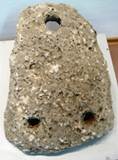
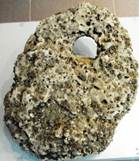
Figure 3. Ancient stone anchors. Source: Town Museum of Kavarna, Bulgaria, HERAS Project Exhibition, photos taken by authors, 2015.
Another proof of sea navigation, in the 5th millenium BC, is the manufacture of ornaments from Spondylus, Cardium, or Dentalium shells, a fashion common mostly to the Balkans, which later reached up the Middle Danube (Lengyel culture) In the 3rd- 2nd millenniums, BC the Minoan and Mycenaean communities opened new routes, for various reasons, i.e. search for raw materials, gift exchange with their neighbours (out of diplomatic reasons), predatory raids, and colonization. According to Hesiod, navigation at sea was taking place especially in summer (about 50 days a year), when the navigators took advantage of the sea currents and wind direction, in order to move their watercrafts along the coast.
At the end of the 2nd millennium, the passage from Troy to the Black Sea used to last 10 to 12 days. The boats sailed along the coast, while at night, or in stormy weather, they moored in sheltered areas. During the Trojan War, the Thracian allies of Hellespont reached the fortress of Troy, by sea. The presence of Coslogeni and Babadag pottery in the Troy destruction level VIIb show the movement of some communities from the north of the Balkan Peninsula to Asia Minor (Bounegru, 2003).
3. History of Ancient Navigation and Trade in the Black Sea
In Antiquity, the navigation in the Black Sea Basin was very difficult, firstly, due to the lack of information about the area, and secondly, due to the adverse conditions existing at the time, i.e. the absence of islands, the rapid emergence of violent storms, or frequent mists.
To reach Pontus Euxinus the ancient seafarers had to pass through the Dardanelles and the Bosphorus straits. Strong winds and currents from the north were a barrier hard to pass through by seafarers who intended to enter the Dardanelles, while navigation in the Bosphorus was also very difficult, due to the geographical conditions, and the very strong currents. For this reason, the Bronze Age Greeks’ entering the Black Sea occured later, and the existence of this (which was questionable for quite a long time), is now confirmed by the recent archaeological discoveries (Irimia, 2008).
The history of ancient navigation shows the activity of the Phoenicians – a nation of sailors, of Chaldean origin, who founded a great number of city – ports, in the 3rd millennium BC, on the Eastern coast of the Mediterranean Sea, thus colonizing the entire Mediterranean basin, reaching the Baltic Sea, the Red Sea and the Black Sea. The Phoenicians were very good traders, and they managed to build commercial outposts, in the areas they passed through. They were also good ship builders; they built heavier ships, with higher boards, with one or more decks, propelled by oars or sails; they were also good sailors, knowing how to guide themselves after the stars (the Pole Star was called the Phoenicians’ Star), and to use the wind for moving, even if it was against it (navigation against the wind- being one of their best kept secret, for centuries (Bârdeanu, 1979).
The presence of the Phoenicians in the Black Sea seems to be confirmed by samples of Syro-Phoenician origin - crockery statues, pearls and pendants with human masks, scarabaei – discovered in the Greek poleis (Histria, Olbia), (Bouzek, 2000). Another seafaring people – the Greeks, contributed to the writing of the history of ancient navigation and trade by sea; driven by the desire to rule the sea, the ancient Greeks colonized the shores of the Mediterranean and of the Black Sea and built citadels and powerful ports - some of which have developed in time, and still existing in our days; they also created the necessary means for domination - ships for war and trade (figure 4), true gems of ancient shipbuilding (Ciorbea, 1996).
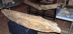
Figure 4. Ancient wooden sailing vessel found near Romanian Black Sea coast - keel fragment. Source: National History and Archeology Museum Constanta, Romania, HERAS Project Exhibition, photo taken by authors, 2015.
Beginning with the 9th century BC the colonization of the Black Sea and of the Mediterranean started to be done regularly, and thenceforth contributed to the flourishing of the Black Sea area. In the 7thcentury, all coastal areas of the known ancient world were crammed with Greek cities, which maintained close relations with the metropolises (figure 5). This intense trade led to a remarkable change in the way commerce was conducted, i.e. people started to trade money instead of goods (Fourakis, 2008).

Figure 5.Black Sea Greek colonization map. Source: processing after http://istorie-edu.ro/istorieuniversala/Grecia/gr_07col.html/Atlas istoric, Editura Didactică și Pedagogică, București, 1971.
Mycenaean Greeks expansion to the Black Sea was imposed both by geostrategic and geo-economic reasons. The first and the second halves of the 2nd millennium BC witnessed the flourishing of the Aegean Sea, while the Black Sea was considered as a geostrategic part of the former.
The colonization of the Pontus Euxinus coast, by the Greeks, began in the 7th century BC when, on the western shore the town – ports of Callatis, Tomis, Histria (figure 6) were established. These settlements have proven their value and vitality through the existence of the current Romanian port of Constanţa, Mangalia, Midia (south of the ancient port Histria), and Tulcea (Ciorbea, 1996).
Figure 6. Ancient ship on an inscription from Histria. Source: Iosipescu, S., Iosipescu, R., Cetăţile greceşti din Pontul Nord-Vestic, Revista de istorie militară, RIM 3-4, Bucureşti, 2008.
In the Black Sea Basin, the ancient sailors practiced both coastal navigation (cabotage), and high sea navigation. The cabotage was practiced along the west coast of the Black Sea, where, regardless of the direction of the main current, the ancient sailors could float in a clockwise motion, near the coast, using the breeze, and the coastal winds, and also the coastal circular current. The second cabotage route was along the south coast. The ships used to float with the main current, 3 to 9 km away from the Anatolian coast, up to Sinope, from where they started to practice high sea navigation, across the Black Sea, reaching the southern Cape of Crimea. The first route might have been used by the Mycenaeans, too; for the second the information appeared later, without excluding, in all, the possibility of the navigators knowing it from an earlier period (Irimia, 2008).
Beyond the legendary adventures of the Argonauts hides the historical reality of the Mycenaean geopolitical development, in the wider area of the Black Sea, farther to the Caucasian coasts. The Golden Fleece symbolizes the desire for adventure and danger, characteristics which were often met with at the beginning of each powerful naval domination, such as the Mycenaean one. The very description of the Golden Fleece is nothing more than the description of the Black Sea coast storehouse which was considered vital for the survival of the Mycenaeans, and later, of the Athenians (Fourakis, 2008).
At the time, another water craft was emerging, i.e. the trireme - a ship for war and expedition, with three banks of oars, with a length of 35 m, a width of 4 m, and a draft of 1.2 m, with a displacement of about 100 tons, with a system of rectangular sails, which could reach speeds of 9-12 knots; it was a light and easily maneuverable ship, having a metal spur at the bow, below the waterline, for attack. Merchant ships were heavier, they had wider hulls, were propelled by sails, and could reach 7 to 8 knots; they also had an impressive load capacity (vessel "Alexandria" built in the time of Hieron II, the tyrant of Syracuse (268-215 BC), a remarkable vessel with a length of 90 m and a displacement of 5,600 tons, built to carry Sicilian products to Egypt), (Manoliu, 1984).
The presence of the Aegean archaeological materials (some of them were extremely valuable) was explained, regardless of the route covered, by the practicing of a distance trade, or through the contacts with the local elites. However, the spread of these prestigious pieces (such as the Mycenaean daggers and swords, or even their imitations) indicates the development of an independent elite in the "barbaric" world. Also, the Aegean goods brought by sea penetrated the Pontic regions, too (Irimia, 2008).
The existence of such links with the Aegean area is archaeologically demonstrated in some areas of the Black Sea coast: on the North Anatolian coast, on the west Pontic coast, on the Ukrainian and Crimean coast. In what the North Pontic region is concerned, these links are documented at least for the period of the Mnogovalikovaja culture, and for the early stage of the Sabatinovka culture. A significant fact for the earlier reports of the North West Pontic regions with the Aegean world is, among other things, the Borodino thesaurus, in the southern part of Bessarabia. A proof for the complex connections with the Mycenaean civilization is the Dudarkov horn ax (attributed to the Mnogovalikovaja culture), on the upper Dnieper river, one of the northernmost pieces of clear Aegean influence discovered so far.
The Black Sea colonies used to receive, from the ancient Greek cities, loads of wine and oil, or ceramic pots that had reached a level close to perfection, in exchange for wheat, dried fish, and other natural products specific for an economy which was mostly pastoral and agricultural, at the time.
Trade by sea was getting more specialized, certain professions like: shipowner, consignor, import-export wholesaler started to delineate.
There was even an Athenian law which stipulated that any vessel engaged in Pontic waters routes shall return home with a cargo of wheat, an element that will be found in the 14th century Venetian shipping regulations (Cojocăraşu, 2008).
The prosperity of Histria, a Milesian colony, in the next two centuries after its foundation, is explained by the active commerce with the Pontic population, and also by the fact that, at the time, it was relatively easy to exploit the rural area (chora), which the fortress managed to take possession of, gradually. The oil, the wines, the handcraft products sold in Histria started to surpass the borders of the fortress, and got to be traded up the river, being profitably changed with grain, honey, furs and animal skins, slaves and especially fish, products that were much needed in the Greek metropolis (Iosipescu, Iosipescu, 2008).
The continuity of navigation and trade on the Danube has been preserved and transmitted by the Geto-Dacians, Daco-Romans and Romans; the history of navigation in these places begins with the Istros known since the time of the Egyptians, who are said to have come up the river as far as to its springs. At first, the Geto-Dacians used both the monoxila and the boat; later, they came to build more advanced boats for sailing, fishing, transport of goods on the inland waters, or on the Danube, as well as for military purposes (figure 7);

Figure 7. Geto-dacian water crafts - bass relief on Columna lui Traian Source: Manoliu, Nave şi navigaţie, 1984.
The Carps sailed the seas for trade and fishing, and also for attacking the Greek colonies on the western coast of the Pontus. During his military expeditions, king Burebista used to cross the Danube, to the South, with his powerful armies, in large boats (Bârdeanu, Nicolaescu, 1979).
In conclusion, the maritime routes that crossed the Pontus Euxinus from south to north and northwest was actually the way in which the Aegeans were able to exercise their political and economic influence, to the north of the Aegean Sea (Irimia, 2008).
Also, for the ancient period the Carthaginians are worth mentioning. They were skilled navigators and merchants who came to trade their goods in Northern Europe and the Black Sea. They even sailed around Africa and the Red Sea; the Carthaginian ships exceeded the first Phoenician ships, being more delicate crafts, entirely decked, with a length of about 18 m, with a solid hull, built in the transversal system, with small distances between the ribs, propelled by a trapezoidal sail, that could provide, in favourable winds, a speed of 7-8 knots (Manoliu, 1984).
Ancient Rome meant a blooming period for navigation and sea trade; the Romans became good sailors only when they understood that one cannot control the land unless they control the seas (figure 8).

Figure 8. Roman sailing vesssel, 2nd-3rd century A.D., fragment of sarcophagus – Odessus, The History Museum, Varna, Bulgaria, photo taken by authors.
From the writings of the Roman poet Ovid, who was in exile in Tomis between 8-17 A.D. (Epistolae Ex Ponto III) there appears that the main occupations of the inhabitants of the Pontic Dacia, that persisted until today, were in agriculture and sheep breeding (Popescu –Spineni, 1978).
During this time shipbuilding developed extensively. It was the time when remarkable ships, renowned for their qualities, were built: the Roman trireme with sails, the liburna, a ship with battle towers, the quadrireme, and the ship for transport or cargo carrier (Bejan, 1994).
Also, the Roman historian Gaius Plinius Secundus (XVII (7), 12, 63, 69) gives us information about the Pont wheat crop, which was of better quality, and more resistant to frost than the wheat from the southern provinces, due to its adaptation to the cold climate in this area (Popescu - Spineni,1978).
In his work De Natura Animalium the Roman historian Claudius Aelianus tells about the occupations of the inhabi-tants of Pont: agriculture, sheep breeding, (sheep were fa-tten with bitter absinthe, i.e. Dobrudja wormwood), bee-keeping (bees were resistant to cold weather), and also Getic horses breeding (which were supposed to have been extremely fast) (Popescu - Spineni, 1978).
After having gained naval supremacy (figure 9) the Romans built new ports, shipyards and supply bases. The seaborne trade flourished from the Western Europe up to the Middle East and the African coasts.
The western Black Sea coast area was part of the freight traffic system of the Greco-Roman world. The goods arriving by sea in the Balkan peninsula provinces were then distributed on the navigable rivers. Among the well-known trade routes we mention Histria - Odessos - Byzantium, Viminacium - Naissus - Thessaloniki, Novae - Philippopolis - Byzantium, Singidunum - Naissus - Hadrianopolis - Byzantium. These routes actually represented the northern branches of the road known as "via Egnatia" which linked the commercial routes of the Balkans and the mouths of the Danube to Asia Minor and the Syro-Palestinian area, through Byzantium. The west, east and south ends of this area were marked by trade centers - Aquileia, Tomis and Thessaloniki. (Bounegru, 2003).

Figure 9. Emperor Trajan Sails on the Danube (XXXIV = 25-26). Source: Vulpe, Trajan’s Column, www.cimec.ro.
The importance of Tomis for the Roman trade in the Black Sea is illustrated by the large number of epigraphic attestations of merchants and sailors existing in the metropolis. Associations of shipowners appeared only in some west coast ports, and on the coasts of Bithinia; we find them in Tomis mentioned in inscriptions. The prosperous trade relations between Tomis and Alexandria are proven by the presence of an association of the Alexandrians (oikos ton alexandreon) that build a temple in honor of Sarapis.
At Histria the presence of a large family of merchants, originnally from Bithinia is attested.
"Tomis was an important commercial warehouse in the western Black Sea, which, having direct links to major commercial cities of Bithinia, allows transit trade from Asia Minor and the Middle East to the mouth of the Danube and even within Moesia" (Bounegru, 2000).
In the Roman-Byzantine period, in the province of Scythia Minor, numerous naval and maritime units were concentrated, along with ground troops. Thus, in the Notitia Dignitatum we find a mention about a small unit called Musculi Scythi, which acted on musculus type vessels, both on the sea coast, and on the Istros. The boat had been widely spread throughout the Roman Empire, being represented, along with other 24 types of ships, on the mosaic from Althiburos (Tunisia), and also on an altar at Histria (figure 10).
Musculus, an asymmetrical boat, without a mast, moved only by oars, relatively small in size, was used for economic and military reasons; these ships sailed efficiently through the lagoon, river and maritime areas.

Figure 10. A Musculus boat representation Museum of Histria Fortress, Romanian Black Sea coast, photo taken by authors, 2013.
In the same passage of Notitia Dignitatium XXXIX, 35 another type of vessel is mentioned, i.e. the plateypegia, a flat-bottom boat that could sail into shallow waters, used in the Nile Delta, starting with the 3rd millennium, A.D. Zomisos writes about the strengthening of the naval and maritime fleet in the area of Scythia Minor, under Emperor Valens, as follows (Popescu - Spineni, 1978):
"He (Valens) saw to it that the military be sent supplies with a large number of ships through the Pontus Euxinus to the mouths of the Danube, and from that point on, by the help of river vessels, so as the supplies be stored in the cities on the river banks, to be within easy reach for the army".
Large vessels used in peacetime for carrying goods are mentioned in the clashes with the barbarians (Avars and Sclavins), in 578 A.D. The Roman troops were transported on such ships. "...what draws our attention is, firstly, the multitude of vessel types, described in these sources (ancient) and, secondly, the fact that broadly speaking the main types of ships for trade and war, belonging to the late Roman era continued to sail until the seventh century A.D. "(Bounegru, 1983).
Finally, we can illustrate the extent of the seaborne trade in Pontos in Antiquity through the ancient wrecks and the multitude of pieces of Hellenistic and Roman ceramics, Hellenistic amphora seals, baked clay figurines, statues, inscriptions and coins discovered by recent underwater archaeological research in the Romanian and Bulgarian Black Sea waters.
Amphorae (Amphoras), which were used, in the Hellenistic and Roman times, to transport food on long and short distan-ces by sea (figure 11, 12, 13).

Figure 11. Amphoras. Source: National History and Archeology Museum Constanta, Romania, HERAS Project Exhibition, photo taken by authors, 2015.

Figure 12. Amphoras. Source: The History Museum, Varna, Bulgaria, photo taken by authors, 2014.

Figure 13. Amphoras. Source: Private colection, Jurilovca, Gura Portitei area, Romanian Black Sea coast, photo taken by authors, 2014.
Roman and Roman-Byzantine amphorae present a much more variety of shapes than the Greek ones. The first tipology was drown at the end of the 19th century by H.P. Dressel, based on a very important early Roman amphorae deposit discovered in Rome. Dressel’s table is still used today, especially for containers produced in the Western parts of the Empire. Among the typologies referring at Hispania and Catalunia we have to mention E. Pelichet and S.J. Keay. Dressel 23 – Keay XIII C Hyspanic amphorae have a glo-bular "lemon" body. There are a few discovered today. They were usually used to carry olive oil to the other provinces of Empire (National History and Archeology Museum Constanta, Exhibit of the month/april 2015).
The content of Roman Amphoras was generally liquid, olive oil or wine, but also garum, the popular fish sauce, and fruit sauce.
During the prospections made by a platform in the Romanian waters, at a depth of 126 m (approx. 90 nautical miles SSE of Constantza harbour – ancient Tomis), an amphora was identified. A ROV (Remote Operated Vehicle) was used to take it to the surface. The amphora, found in a very good condition, represents something unique for the West Pontic coast area. According to all probabilities it represents a Hyspanic amphora (figure 14), (National History and Archeology Museum Constanta, Exhibit of the month/april 2015).
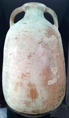
Figure 14. Bag – shaped form Roman Amphora used for storage and transport of olive oil (3rd-4th centuries A.D.), Source: National History and Archeology Museum Constanta, Romania, Exhibit of the month/april 2015, photo taken by authors, 2015.
The Roman Edifice with Mosaic discovered in Tomis is the best evidence for the economic activity that took place in this area (figure 15, 16).The Edifice was in use from the first half of the 4th century up to at least the end of the 7th century. The majority of the archaeological context sustains this. It is possible that the presence of this commercial centre determined the destination of the ship carrying the amphora with the precious oil (National History and Archeology Museum Constanta, Exhibit of the month/april 2015).
Figure 15. The Roman Edifice with Mosaic-0utside picture, National History and Archeology Museum Constanta, Romania, Source: photo taken by authors, during HERAS Project, 2014.

Figure 16. The Roman Edifice with Mosaic-inside picture, National History and Archeology Museum Constanta, Romania, Source: photo taken by authors, during HERAS Project, 2014.
4. Conclusions
With its theme the present paper represents the authors’ first attempt to address an interesting, vast and complex issue, i.e. bringing together knowledge of history, geography, archeology, navigation and ships, economics etc.
The history of navigation and trade in the Black Sea goes back as far as the first human settlements established on the Pontus coasts.
The Greek colonization of the Black Sea coasts is part of the centuries-old process of the Greek expansion and colonization in the Mediterranean Sea.
The ancient Greeks founded many colonies on the Pontus coast that survived hundreds and even thousands of years, some of them existing today in the form of prosperous cities and ports. This shows that the ancient Greeks were able to wisely choose the places for setting up their colonies, at the Pontus Euxinus.
Ancient Rome was able to maintain and even develop many of the Greek colonies in Schytia Minor used as outposts of the Roman Empire in this area.
References
- Bărbuneanu, I. 1975, Mările şi oceanele Pământului, Ed.Militară, Bucureşti, p. 22.
- Bârdeanu, N., Nicolaescu, D., 1979 Contribuţii la istoria marinei române, vol.I, Ed. Ştiinţifică şi enciclopedică, Bucureşti, p. 13-14
- Bejan, A., Bujeniţă, M. 1979, Dicţionar de marină, Ed.Militară, Bucureşti, p. 13-15.
- Bejan, A. 1994, Războiul naval de-a lungul veacurilor vol. I, Ed.Tehnoprod, Bucureşti, p. 33-35.
- Boşneagu, R., 2004, Influenţa condiţiilor geografice asupra rutelor de transport în bazinul Mării Negre-sectorul vestic, Ed. Cartea universitară, Bucureşti, p. 8-9.
- Bounegru, O., 1983, Tipuri de nave la Dunărea de Jos în secolele IV – VII e.n., Pontica 16, p. 273 – 280.
- Bounegru, O., 2003, Economie şi societate în spaţiul ponto-erean (sec.II a.Chr. – III p.Chr.).
- Bouzek, J., 2000, Les Phéniciens en Mer Noire ?, vol. Civilisation greque et cultures antiques périphériques (eds. Al Avram, M. Babeş), p. 134 – 137.
- Brătianu, Gh., 1988, Marea Neagră, vol. I – II, Ed.Meridiane, Bucureşti, p. 17-19.
- Ciorbea, V., 1996, Portul Constanţa 1896 – 1996, Ed. Fundaţiei Andrei Şaguna, Constanţa, p. 123-124.
- Ciorbea, V., 1996, Portul Constanţa de la antichitate la mileniul III, Ed. Europolis, Constanţa, p 22-24
- Cojocăraşu, S.,Callatis, legenda Mării Negre, Marea Neagră, file de istorie universală,http://www. alternativaonline. ca/StudiiPontice1107.html
- Crăciunoiu, Cr., 1979, Navomodele, vechi nave româneşti, Ed. Sport-Turism, Bucureşti, p. 44-45.
- Depastas, N., Grecii din Euxin în antichitate şi evul mediu, Revista de istorie militară, RIM 3-4, 2008, p.17-19
- Fourakis, P., Marea Neagră şi începuturile geopoliticii elene,Revista de istorie militară, RIM 3-4, 2008, p.4-6
- Irimia, M., Unele aspecte privind raporturile dintre spaţiul egeean şi regiunile istro-pontice în bronzul timpuriu, Zargidava - Revistă de istorie, VIII, Bacău, 2008, p. 27-29
- Iosipescu, S., Iosipescu, R., Cetăţilegreceşti din Pontul Nord-Vestic, Revista de istorie militară, RIM 3-4, 2008, p.10
- Hiller, St., 1991, The Mycenaens and the Black Sea, Thalassa, p. 207 – 211.
- Marinescu-Bîlcu, S., Voinea, V., Dumitrescu, St., 2000-2001, Aşezarea eneolitică de pe Insula „La Ostrov", Lacul Taşaul, Năvodari.Raport preliminar – campaniile 1999 – 2000, Pontica 33 - 34, p. 123 – 170.
- Manoliu, I., 1984, Nave şi navigaţie, Ed. Ştiinţifică şi enciclopedică, Bucureşti, 1984, p. 67-70.
- Schuster, C., Morintz, Al., 2009, Ambarcaţiuni şi navigaţie în preistorie, Editura Cetatea de Scaun p.12-14, 21-22, 34-36.
- Tončeva, G., 1981, Un habitat lacustre de l’âge du Bronze ancien, Thracia Pontica 1, p. 176 – 182.
- Popescu-Spineni, M. 1978, România în izvoare geografice şi cartografice, Din antichitate pînă în pragul veacului nostru, Editura ştiinţifică şi enciclopedică, Bucureşti, p. 25, 30, 36-40, 45, 49
- Vulpe, R., 2002, Columna lui Traian, Trajan’s Column,www.cimec.ro, p 134.
- ***Cartea HERAS, Submarine Archaeological Heritage of the Western Back Sea Shelf- HERAS Project, CBC Programme, 2007-2013, p. 22-24, www.herasprojectcbc.eu/media/


