
American Journal of Geophysics, Geochemistry and Geosystems, Vol. 2, No. 2, April 2016 Publish Date: Jul. 15, 2016 Pages: 15-22
Structural Framework and Petrology of the Sedimentary Rocks in Parts of the Western Flank of Ikom – Mamfe Basin, Southeastern Nigeria
Efosa Udinmwen*
Department of Geology, University of Calabar, Calabar, Nigeria
Abstract
The study area is part of the western flank of the Ikom – Mamfe basin and contains sedimentary rocks which are made up of basically sandstones with minor mudstone, limestone and shale. Thin section analysis show that the sandstones are probably lithic sub-arkosic sandstone with a parent material most likely of igneous or metamorphic origin. The limestone and mudstone occur as thin beds within sandstone and the shales are baked in some cases. Sediments in the study area were probably deposited in high and low energy environments characterized by shallow and deep marine transgression events which led to the deposition of limestone and black shale respectively. The bedding planes in the sedimentary rocks dips gently and are cut by fractures oriented in the NW – SE/ESE – WNW, NNW – SSE, ENE – WSW and NNE – SSW directions. The fracture characteristics support the occurrence of two episodes of deformation in this basin.
Keywords
Ikom – Mamfe Basin, Fracture, Sandstone, Limestone, Shale
Received: June 18, 2016
Accepted: June 30, 2016
Published online: July 16, 2016
@ 2016 The Authors. Published by American Institute of Science. This Open Access article is under the CC BY license. http://creativecommons.org/licenses/by/4.0/
1. Introduction
The study area is a part of the Cretaceous cover of the Ikom – Mamfe basin (Fig. 1). It predominantly contains sedimentary rocks with some intrusive bodies intruding the Cretaceous sediments (Fig. 1) whose thickness range from less than 1 km to about 4 km [1 – 3]. In the Ikom – Mamfe basin, there are paralic sequences of the marine transgressive cycles. [4] noted that these cycles were from changes in sea level in which limestone and shale were deposited on fluviatile sandstones, providing a tool for the division of the basin into Eze-Aku Group (Late Cenomanian – Early Santonian) and Asu River Group (Albian-Early Cenomanian). The study area is part of the western flank of the Cretaceous cover of the Ikom-Mamfe basin which is 130 km long and 60 km wide, extending east from the lower Benue Trough, Nigeria, into Cameroun where it narrows and terminates beneath the tertiary to recent volcanic cover of the Cameroon volcanic line [5]. This area has consistent highs and lows with gentle slopes and the highest point within the study area is 100 m while the lowest point is about 20m. The area is made up of Albian sandstones and limestones followed by a sequence of lower Turonian sandstones and shales all of these being intruded by post – Turonian minor basic to intermediate intrusion [6]. The oldest sedimentary sequence is the sandstones and the limestones which formed thin beds in between the sandstones. A series of interbedded grey to black shale and siltstone with frequent facies change to sandstone, calcareous sandstone, sandy limestone and sandy shale constitutes the rest of the area. All the sedimentary rock units found in the area are fossiliferous and based on lithology and fossil character are considered to be part of the Eze Aku Formation [6]. Two (2) basic to intermediate igneous bodies (gabbro and dolerite) of different sizes and shapes, mostly concordant to the country rock was observed in the mapped area, these intrusions occurred either as minor sills or as minor mushroom - like plutons [7,8].
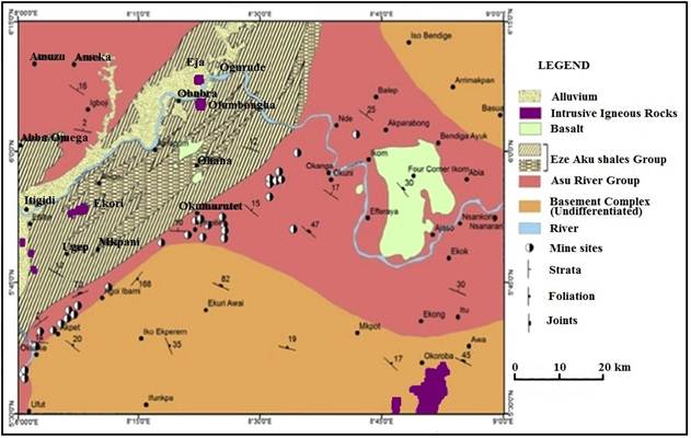
Fig. 1. Geologic and structural map of western Ikom – Mamfe basin, southeastern Nigeria (Modified after [9]).
2. Methodology
This study involves the detailed mapping of rocks and structures within the study area. The field mapping was carried between May 2011 and June 2011. Detailed mapping of parts of the western flank of the Ikom – Mamfe basin was done on a topographic map with a scale of 1:25,000 covering an area of over 80 Km2. The map was sub divided into 25 grids with each grid covering about 3.45 Km2. The geology and structures each grid was mapped systematically. The major equipment’s used for this study includes a Garmin 76 Global Positioning System (GPS), Silva Compass Clinometer and a measuring tape while hydrochloric acid (HCl) was used in testing for the presence of carbonates in rocks (test for effervescence) in the field. The attitude of structures particularly bedding planes and fractures were measured using standard structural techniques and presented using stereographic projection and rose diagram. Thin sections were prepared by mounting a 0.03mm of the rock sample on a 25mm by 45mm glass slide with epoxy having a refraction index of 1.54. The minerals in the thin sections were identified using an Olympus petrological microscope and Zeiss WL microscope.
3. Results
3.1. Geology
Sedimentary rocks are the dominant rock type in the study area and occupies between 90-95% of the total mapped area with sandstones been the most frequently occurring rock. Three major types of sedimentary rocks occur in the area which are sandstones, mudstone, limestone and shale and these were deposited between the Albian and Lower Turonian thus the rocks of this area belongs to both the Asu River Group and the Eze Aku Formation. All the rock units of both the Asu River Group and Eze Aku Formation are roughly striking N40°E with dips ranging from 9° to 20° [6].
3.1.1. Sandstones
Sandstones are the most frequently occurring sedimentary rocks in the mapped area and they cover about 80% of the total area. Four (4) types of sandstones were observed which are calcareous sandstones, shaly sandstones, weakly consolidated sandstones and highly consolidated/competent sandstones. All these sandstones are fossiliferous (Fig. 2) save the weakly consolidated sandstones and they are fractured to varying degrees (Fig. 3). The calcareous sandstone is the most widely occurring in the mapped area, they are highly fossiliferous with frequent brachiopod cast/mould and they sometimes occurs as caves with underlying grey shale. They show little effervescence upon reaction with an acid indicating the presence of small quantity of carbonates, these were formed in a low energy environment as their grain size is fine. The calcareous sandstone is usually medium grained and usually grey in colour.
The shaly sandstone is the least frequently occurring and is found only in a few locations. They occur with little grey shale, while pure grey shale are usually observed a short distance away. They are fine grained and dark grey in colour.
The weakly consolidated sandstones are also widely occurring. They are usually found along stream channels and are medium to coarse grained and are in some cases pebbly. They also occur as caves and are usually whitish in colour. They are completely devoid of fossils. With respect to the calcareous sandstones, these sandstones seem to be deposited in a higher energy environment.
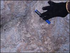
Fig. 2. Fossils in sandstone.

Fig. 3. Jointing in sandstone.
The highly consolidated/competent sandstones are frequently occurring in the study area. Their exposure is usually small but is sometimes extensive and massive and has limestone within it. This is the only fresh and competent sandstone with intercalated limestone. Macrofossil casts (bivalves) were also observed. They are usually fine grained and are grey to dark grey in colour. In general, all these various sandstones were bedded and had bedding planes with dip angles between 4o to 20o mostly in the NE and SE directions. The highly competent sandstone was found to be lithic sub-arkosic sandstone after petrographic analysis.
3.1.2. Limestones
Limestone covers about 5% of the mapped area and these are highly restricted to the southern part of the map, about 4-5km SW of Ekori town. They occurred as thin beds (less than 1m thick) between weathered sandstones but they remain fresh (Fig. 4). It showed high effervescence upon reaction with acid confirming the presence of carbonate minerals. They are light grey, fine to medium grained and had trace fossils (i.e. little burrows). Rapid marine transgression and regression could be the deposition mechanism of these thin bedded limestones between sandstones.
3.1.3. Shales
Just like limestones, shales covered about 5% of the total mapped area and were found in few locations. They vary in colour from grey to black. The black shales are baked shales (Fig. 5) and these were baked by a gabbroic intrusion which has a sharp contact with the baked shale along a stream channel. Most of the grey shales occur underneath a sandstone cave and their extent is quite small compared to the overlying sandstone.
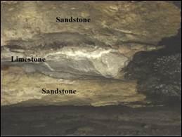
Fig. 4. Limestone sandwiched between weathered sandstones.
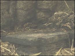
Fig. 5. Baked shale in the study area.
3.2. Structural Analysis
A total of 149 joints were measured from the study area. It must be noted that majority of the joints (85%) were measured from the sandstones as joints were not penetrative in the shales and due to the occurrence of the limestone (i.e. as thin beds in-between sandstones) it was impossible to measure joints. Most of the joints have high angle dip (75 - 90o; (Fig. 6) and a few vertical joints were observed. In most cases, the fractures were perpendicular to the bedding planes. The bedding planes in the sedimentary rocks had variable strike values with low angle dips (4o-20o) usually in the SE direction (Fig. 7).
It is observed from the stereographic projection that the poles of the beds are clustered around the center of the stereonet indicating that most of the bedding planes have low angle dips.
This section serves to analyze the structural measurement gotten from the study area and their implication to the general geology of the area.
The joint data from the study area were projected on the Lambert equal area stereonet as poles (Fig. 6) and also presented in a rose diagram (Fig. 8). From Fig. 6, at least four fracture sets can be identified in the rocks of this region. A dominant NW – SE/ESE – WNW fracture set is supported by minor NNW – SSE, ENE – WSW and NNE – SSW.
It is observed from the stereographic projection that the poles to the joints are clustered around the periphery of the stereonet indicating that most of the joints have high angle dips, also poles occur round the stereonet indicating that all directions were represented but more poles are found in the NE-SW direction indicating that the general trend of the joints is NW-SE which is typical of the first deformation episode of the Cretaceous. These high angle dips are typical of the ‘ac’ extension and ‘bc’ tensile fractures.
From Fig. 8, it is observed that at least four fracture sets occurs in this area which are the dominant NW – SE/ESE – WNW fracture set supported by minor NNW – SSE, ENE – WSW and NE – SW.
3.3. Petrology
Petrology is concerned with the study of rocks that are made up of definite mineral assemblages, it deals with the mode of occurrence, composition, classification and origin of the rocks with their relationship to geological processes and history. There are three (3) major sedimentary rocks found in the study area, they are; sandstone, limestone and shale/baked shale. The texture of the sandstones collected from the mapped area is mostly fine grained and they are light grey in colour.
3.3.1. Sandstone
Based on the modal composition of quartz, feldspar and the rock fragments (Fig. 9), this rock is most likely lithic sub-arkosic sandstone. The occurrence of 50% of quartz and 20% of feldspar indicates that the parent material is most likely an igneous or metamorphic rock, a sedimentary parent rock would have produced a sandstone with almost entirely quartz. The percentage of quartz also justified the high competence of the sandstone and its grey colour which was observed macroscopically in the field.
The percentage of quartz (60%), feldspar (20%) and rock fragment (Fig. 10) again shows that this sandstone is most likely a lithic sub-arkosic sandstone but the percentage of feldspar indicates that the environment experienced rapid erosion and burial because feldspars are unstable in the sedimentary environment. This rock is also very competent and grey in colour.
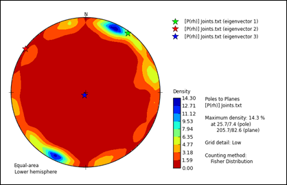
Fig. 6. Stereographic projection of joints in the study area.
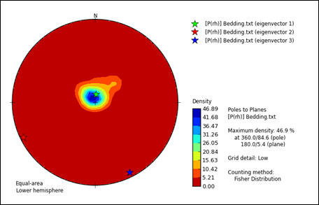
Fig. 7. Stereographic projection of bedding planes in the study area.
3.3.2. Shale
This shale was baked as a result of a granitic intrusion (gabbro) which occurred nearby. The clay minerals cannot be delineated under the microscope, they just show a black colour and occupied about 65% of the rock while pyrite (30%) was clearly observed with its gold colour (Fig. 11) which was also observed macroscopically. This rock is called "Baked shale".
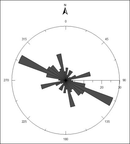
Fig. 8. Rose diagram of joints in the study area.
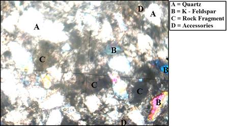
Fig. 9. Thin section photomicrograph of sandstone from the study area.
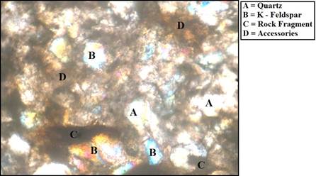
Fig. 10. Thin section photomicrograph of sandstone from the study area.
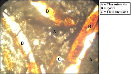
Fig. 11. Thin section photomicrograph of baked shale from the study area.
3.3.3. Limestone
This rock is light grey in colour and showed high effervescence when reacted with Hydrochloric acid, this was justified by the occurrence of 60% of calcite (Fig. 12) which is the cementing material of the rock. The rock is thought to be a limestone.
4. Discussion
The study area covers communities such as Ekori, Ugep, Nko and Mkpani within the western flank of the Ikom – Mamfe basin. The sedimentary units of this region are made up of basically sandstones of different types with minor mudstones, limestones and shales. The sandstones were separated into four types based on macroscopic observation, physical properties and mode of occurrence. The different types of sandstones include calcareous sandstones, shaly sandstones, weakly consolidated sandstones and highly consolidated/competent sandstones. The sandstones contain different types of fossils (Fig. 2), most notably bivalves and brachiopods and sometimes form semi – caves beneath which grey shales occur. The limestones and mudstones occurs as thin beds within the sandstones with the calcite in limestone displaying high relief which changes as the stage is rotated. In some cases, the shales are black in colour and baked with pyrite mineralization (Fig. 11) as a result of gabbro and dolerite intrusion which are wide spread in the Ikom – Mamfe basin [6,10]. The Ikom – Mamfe basin is quite similar to the Benue Trough in terms of tectonism, magmatism, stratigraphy, sedimentology and even mineralization. The Ikom – Mamfe basin just like the Benue Trough experienced repetitive cycles of marine transgression and regression [11] and this explains the occurrence of thin limestone beds within sandstones which indicates rapid shallow marine transgressive and regressive cycles. The presence of black shales in the area suggests the possibility of deep marine incursion in the region. The energy of the environment in which the sandstones were deposited varies between high and low – energy environments ass we have a combination of fine grained and pebbly sandstones in the study area. Two episodes of deformation are known to have affected this basin in the Lower Cretaceous and the Upper Cretaceous [6,9,12]. The fractures of the deformation episodes have been classified into ac1, bc1, ac2 and bc2 based on fracture kinematics and the relationship between fracturing and folding [8] as folds and ridges are believed to exist in the Ikom – Mamfe basin [13,14,9] from stratigraphic and structural evidence although no mesoscopic observation is available thus presently, there is no map showing the trace of the axial plane of these folds in the Ikom – Mamfe basin [12]. The ac1 and bc1 represent the extension fractures of the first episode of deformation (Lower Cretaceous) while ac2 and bc2 represent the extension fractures of the second episode of deformation (Upper Cretaceous). The fractures in the study area are mostly extension fractures with high angle dips (Fig. 6) and are perpendicular to the bedding planes which dips gently (8°– 20°) and it is mainly oriented in the NW – SE and NE – SW directions (Fig. 7). The fractures are oriented in the NW – SE/ESE – WNW, NNW – SSE, ENE – WSW and NNE – SSW directions (Figs. 6 and 8). The NW – SE and NNE – SSW are the most prominent fractures in the study area and they are the ac1 and ac2 fractures of the Lower and Upper Cretaceous deformation episodes respectively. This shows that the study area just like the entire basin have affected by two episodes of deformation. Thin section analysis revealed that the most of the sandstones are most likely lithic sub-arkosic sandstone and the occurrence of 50% of quartz and 20% of feldspar indicates that the parent material is most likely an igneous or metamorphic rock, a sedimentary parent rock would have produced a sandstone with almost entirely quartz. The percentage of quartz also justified the high competence of the sandstone and its grey colour which was observed mesoscopically in the field.
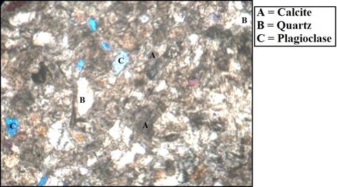
Fig. 12. Thin section photomicrograph of limestone from the study area.
5. Conclusion
The sedimentary units of parts of the western flank of the Ikom – Mamfe basin show different variety of sandstones with minor mudstones, thin bedded limestone and shales. The thin limestone beds intercalated with sandstone suggest the occurrence of shallow marine transgression and regression event in this basin. The presence of black shales indicates the possibility of deep marine incursion while the variety of grain size of sandstones from fine grained sandstones to pebbly sandstones suggest a mixture of low and high energy environment of deposition. Fracture behavior supports the occurrence of two episodes of deformation in this basin while thin section analysis indicates the sandstones are probably lithic sub-arkosic sandstone and the parent material is most likely of igneous or metamorphic origin.
Acknowledgement
My unreserved gratitude goes to my academic father, Dr. Michael I. Oden who designed this study and introduced me to structural analysis of rocks. I am grateful to Williams DD, Frank UM, George EO, Osaji EO, Ekunke and Egbongi who assisted me in no small way during field data acquisition. The chiefs and elders of Ekori community are highly appreciated for their hospitality during the field mapping period. Dr. Ekere E. Ukwang is thanked for preparing the photomicrographs and my field guide, Okala cannot be forgotten for his role in making sure that all areas of the community are accessible and safe.
References
- Petters, S.W., Okereke, C.S. and Nwajide, C.S. Geology of the Mamfe Rift. In: Matheis, G. and Schandelmeier, H., Eds., Current Research in African Earth Sciences, Balkema, Rotterdam, 1987, 299-302.
- Nguimbous-Kouoh, J.J., Takougam, E.M.T., Nouayou, R., Tabod, C.T. and Manguelle-Dicoum, E. Structural Interpretation of the Mamfe Sedimentary Basin of Southwestern Cameroon along the Manyu River Using Audiomagnetotellurics Survey. ISRN Geophysics, 2012, 1–7.
- Obi, D.A., Obi, E.O and Okiwelu, A.A. Basinal configuration and intrasediment intrusives as revealed by aeromagnetics data of south east sector of Mamfe basin, Nigeria. IOSR Journal of Applied Geology and Geophysics, 2013, 1 (5), 1–8.
- Reyment, R. A. and Murner, N. A. Cretaceous transgressions and regressions exemplified by the south Atlantic. Spec. Bull. Paleout. Soc. Japan. 1977, 21, 246-261.
- Fairhead J. D., Okereke C. S. and Nnange J. M. Crustal structure of the Mamfe basin, West Africa, based on gravity data. Tectonophysics, 1991, 186: 351-358.
- Hossain, M. T. Geochemistry and Petrology of the Minor Intrusives between Efut Eso and Nko in the Ugep area of Cross River State, Nigeria. Jour. Min. Geol, 1981, 18 (1):42-51.
- Udinmwen, E. The geology of Ekori and environs and structural analysis of Ikom and Ohana basalts Unpublished B.Sc Project, 2012, Department of Geology, University of Calabar, p.121.
- Umagu, C.I. Cretaceous intrusives of part of the Ikom – Mamfe basin: Petrographic and structural studies. Unpublished M.Sc Thesis, University of Calabar, 2015. p156.
- Oden, M.I., Egeh, E.U and Amah, E.A. The Ikom – Mamfe basin Nigeria: A study of fracture and mineral vein lineament trends and Cretaceous deformations. Journal of African Earth Sciences. 2015, 101; 35–41.
- Oden, M.I., Udinmwen, E and Esu, E.O. The dolerites of Cross River State (DCRS): physical and mechanical properties. Environment and Natural Resources Research, 2013, 3 (1), 135–143.
- Etuk, E. E., Ukpabi N. Ukaegbu, V. U., Akpabio I. O. Structural evolution, magmatism and effects of hydrocarbon maturation in the lower Benue trough: A case study of Lokpaukwu, Uturu and Ishiagu. Pacific Journal of Science and Technology, 2008, 9 (2), 526–531.
- Oden M.I, Umagu C.I, Udinmwen, E. The use of jointing to infer deformation episodes and relative ages of minor Cretaceous intrusives in the western part of Ikom – Mamfe basin, southeastern Nigeria. Journal of African Earth Science. 2016, DOI:10.1016/j.jafrearsci.2016.02.010.
- Bassey C. E., Eminue, O. O. and Ajonina, H. N. Stratigraphy and depositional environments of the Mamfe Formation and its implication on the tectonosedimentary evolution of the Ikom-Mamfe Embayment, West Africa. Central European Journal of Geoscience. 2013, 5 (3), 349–406.
- Njoh, O.A., Nforsi, M.B. and Datcheu, J.N. Aptian- Late Cenomanian Fluvio-Lacustrine Lithofacies and Palynomorphs from Mamfe Basin, Southwest Cameroon, West Africa. International Journal of Geosciences, 2015, 6, 795-811.


