
American Journal of Geophysics, Geochemistry and Geosystems, Vol. 1, No. 3, August 2015 Publish Date: Jul. 16, 2015 Pages: 71-76
Mapping of the Forests Geosystems Southern Taiga in Mid-Siberia with the Use of the Мк-4 Camera
Ekaterina Kuzmenko*
Institute of Geography, Russian Academy of Sciences, Siberian Branch, Ulanbatorskaya Str., Irkutsk, Russia
Abstract
The paper describes the present the characteristic the up-to-date state and the dynamics of the forest vegetation in the south-eastern part of the Angara-Yenisei region. One of the promising methods of fulfilling a given task in order of the main types of boreal forests in mid-Siberia is to research the forest communities and to type them on the landscape and geosystems basis. In this case there is an attempt to make a transition from the phitocenotic classifications to the geographical-genetic ones. For this purpose we used the classical notions about the invariant of the geosystems and about the genetic type of a forest. We found the main regularities of the spatial-temporal dynamics and of the changes of the forest vegetation in this part of the region. In the process of making a legend to a fragment of the map of forest vegetation the derived forests and the indigenous ones were united. The following indicators of the growing conditions were chosen: a high-altitude belt, a geo-morphological complex, a relief element, the characteristics of the soils and the moistening as well as the position (the stage) in the age-regeneration rows. As an example we give a fragment of a computer-made map (the south-eastern part of the Angara-Yenisei region). To prepare the computer-made map of forest vegetation in the south-eastern part of the Angara-Yenisei region we used a multifunctional adaptable geo-information МАGIS-32 system, designed by the Siberian scientific–publishing and manufacturing centre of geo-information and applied geodesy. In the process of making the map we used a multifunctional adaptive geo-informative МАGIS-32 system. During the mapping the colour synthesised photos, obtained with the help of the Resurs-О satellite (we used the MK-4 camera), were automatically processed.
Keywords
Age-Regeneration Dynamics, Forest Vegetation, Geosystems, Genetic Type of a Forest, Mapping, Satellite-Made Photos
Received:June 10, 2015
Accepted: June 29, 2015
Published online: July 15, 2015
@ 2015 The Authors. Published by American Institute of Science. This Open Access article is under the CC BY-NC license. http://creativecommons.org/licenses/by-nc/4.0/
1. Introduction
Forest ecological systems in mid-Siberia play an important role in supporting the structural carbon balance and the balance of mineral materials. These ecological systems are able to regulate themselves to a great extent and to establish a balance of substance circulation in the environment. This is particularly important in conditions of great anthropogenic forest disturbances in the south of mid-Siberia. In a number of parts of the Angara-Yenisei region, intensive impact to the forest over a considerable area has led to the replacement of climactic fir-pine forests by less productive secondary ones. This has resulted in non-characteristic cycles of carbon circulation. The process is connected with a disastrous change of the ecological-geographical factors and first of all with the increase of the continental features of climate against the background of its change on a global scale.
A considerable part of the forests in the south of mid-Siberia are represented by reforming ecological systems of different ages. In forests of different ages there are different types of carbon accumulation and biological carbon circulation. When studying such forests it is especially important to undertake intergrated ecological – geographical research to assess long-term changes in the forests as a result of their use. With this purpose in mind it is necessary to study the age-regeneration dynamics and the succession dynamics of the forests, and to reflect this both in map models and in multifunctional mathematical models of carbon circulation.
We give the characteristic features of the present state and dynamics of forest vegetation in the south-eastern part of the Angara-Yenisei region with a computer-made map as an example using the MAGIS-32 system and automatic processing of digit satellite images with the help of the MK-4 camera.
2. Data and Methods
2.1. Study Area and Idea Classification of the Forests
One of the promising methods of fulfilling the task of making a dynamic model of carbon distribution among the biological components in the main types of boreal forests in mid-Siberia is to study forest communities and to determine their type on a landscape basis when an attempt is made to move from phytocenotic to geographic-genetic classifications. For this purpose we used classical notions, concerning the study of forest dynamics and well-known in geo-botany, landscape and forest studies, of the invariant of geo-systems and the genetic type of a forest (Коlesnikov 1958; Sochava 1978; Кrauklis 1979; Smagin 1985; Мikheyev 1987; Smolonogov 1990; Smolonogov and Zalesov 2002; Belov and Lemkin and Sokolova 2002). Methods of automatic processing of satellite images with the help of the GIS-technologies are used to obtain the computer-made maps (Коnovalova and Каpralov 1997; ArcView GIS-manual 1999; Кuzmenko and Smolonogov 2000 а,b, 2002; Kuzmenko and Ulebina 2002; Kuzmenko 2001; Kuzmenko and Smolonogov 2002, Multifunctional adaptable GIS (MAGIS-32) manual 2000; Kuzmenko, Mikheev, 2008).
2.2. Sampling Methods
Analysis of taxonomic tables of forest types in the southern taiga of the Angara region has shown that it is not a connection between secondary birch, aspen, and pine forests with the climactic forests in place of which they grow. Consequently there is no clear-cut spatial-ecological positioning of these forest types. The tendencies of their formation are not clear, and later on difficulties appear in determining the carbon cycles in communities with indefinite type of succession-temporal changes. For a number of forest types there is no differentiation as to their high-altitude positions or as to their geo-morphological complexes. In the process of making a legend to a fragment of the map of forest vegetation (the south-eastern part of the Angara-Yenisei region) the secondary forests and the climactic ones were united. The following indicators of the growing conditions were chosen: a high-altitude belt, a geo-morphological complex. In determining the legend for the part of the map of forest vegetation in the south-eastern part of the Angara-Yenisey region secondary and primary types of forest were combined. As indicators of conditions of their occurrence the following were chosen: altitude belts, geomorphologic complex, the element of relief, soil characteristics and moisture (Fig. 1).
To make a fragment of the map we used topographical, geo-morphological, forest, soil maps, forest inventory materials, materials resulting from landscape-ecological studies and the stationary study (Кrauklis 1979; Suvorov 1980; Каlashnikov 1987). The synthesised summer colour photos obtained from the Resurs-F satellite with the help of the MK-4 camera (9 – 11m.) were automatically processed the type forests, areas of the fires and large cuts.
Growing conditions and relation to the landscape are determined for forest communities. The dynamic classification and the legend was made up bearing in mind the altitude factor of the forest. Four high-altitude belts were chosen: the middle mountainous belt with larch mountainous taiga-forests (500-600 meters above sea level), low mountain and foothill belt with the southern boreal fir - Siberian-pine and Siberian-pine – fir forests (400-500 meters above sea level), a belt of high mountain catchment plains with the southern Siberian-pine – spruce - fir forests (250-400 meters above sea level) and the taiga-complex of river plains, terraces and slope-and-valley areas. In every high-altitude belt four most typical orographic complexes were singled out: 1) watersheds or plateau and adjacent top parts of slopes, 2) sloped relief elements, 3) gently sloped and concave watersheds and slopes (catchment depressions), 4) river valleys. The third group of ecological factors defines the peculiarities of the ecological regime of the territory and on the whole characterises the type of the growing conditions. It is connected with elements of structural relief, slope exposure, moisture, and soil characteristics.
To study the forest communities were grouped into successive rows of genetic forest types, taking into consideration the altitude belt, orographic complex, type of the growing conditions and age of the stand. To prepare the computer-made map of forest vegetation in the south-eastern part of the Angara-Yenisei region we used a multifunctional adaptable geo-information МАGIS-32 system, designed by the Siberian scientific–publishing and manufacturing centre of geo-information and applied geodesy (the Sibgeoinform centre) (Kuzmenko and Ulebina 2002). In the first stage, the map was digitised in A3 format. Then the digitised map was checked for correspondence with the MAGIS model. It was then converted to HTML format (the МАGIS system). And finally, the МАGIS project was formed. Then a library of the conventional signs for the map of forest vegetation (1:200000) was elaborated, and the structure of the information based on the digital information classifier for the given fragment of the map was formed. The computer-made map of the south-eastern part of the Angara–Yenisey region was recorded on 2 CDs using the inner format of the МАGIS system. The CDs also contain the spatial databases, semantic databases, the libraries of the graphic attributes and the software. (The software manual is given with the CD).
3. Results
Study of the forests in the landscape areas of the south-eastern part of the Angara-Yenisei region and comparison of the plots studied for distribution of the main forest-forming tree types and dominant forest types showed that in the southern taiga-forest there are considerably diverse ecological systems with fragments of coniferous forests and their secondary birch-aspen forest variants. The state of the landscape structure intensifies or weakens the impact of global tendencies of environmental change on the role of coniferous trees in the forest forming process of the region.
The fragments of the maps (Fig. 1) make it clear that the structure of forest cover is formed under the influence of the vertically organised altitude belts and has four levels from the mountain-taiga, mainly larch, pine - larch, larch - pine forests in the belt 500-600 meters above sea level, to the low mountain foothill fir – Siberian-pine and Siberian-pine - fir forests on traps in the belt 400-500 meters above sea level. The forests situated on convex and flattened watershed plains represented by Siberian-pine – spruce – fir herbaceous green-moss communities in the belt 250-400 meters above sea level. A particular landscape structure is formed by the taiga-forest of river valleys, terraces and the slope-plain plots. In fact in practically all forest belts, there are fir forests that are independent genetic forest types and that greatly differ in stand structure and species diversity, functional features, natural cycles of the age-regeneration dynamics and, consequently, in the types of accumulation of assimilated carbon and its biological cycles. An even more complex picture of temporal changes occurs after anthropogenic impact.
The maps make it clear that the structure of the forest covering is formed also under the influence of the fires and larger cuts. Comparison of a fragment of the forest vegetation map with of a fragment of the map (image 1953) shows that over the last 40 years the area of birch-aspen forests has increased to cover 45-60 % by comparison with 1953 when it covered only 15-20 %. Considerable anthropogenic impact is characteristic of other parts of the areas studied.
This allows us to draw a conclusion that the majority of the communities, consisting of birch-aspen forests, are stable secondary biogeocenoses that have replaced disturbed coniferous forests. Analysis of a fragment of the map shows that similar transformation of coniferous forests into birch-aspen ones is not only of local character but also of regional character under the influence of changes in the landscape. Destruction of coniferous forests that are a powerful factor in forming the environment brings about a sharp change in the ecological situation. The climate becomes more continental, and there is a lack of moisture in the air in spring and early summer when relative air moisture in coniferous communities often drops below 20%. Erosive processes and top soil degradation develop. Global climate change tendencies are characterised by warming in the northern hemisphere and an increase in moisture in the mountains of southern Siberia, which can be observed since the 1930s (Vaganov and Shiyatov and Mazepa 1996). According to V. I. Vlasenko et al. (1999) such climate changes bring about the reinforcement of fir-trees in some areas of the Eastern Sayan mountains. It is possible that such a tendency takes place in the middle mountainous belt of the south-eastern part of the Angara-Yenisey region where there are still large areas of fir forests, but in the Lower Angara region a spread of the range of fir-trees is not observed, in spite of the improvement in climatic conditions for this species.
The structure of forest cover is influenced considerably by endogenic factors. With the decrease in the extent of coniferous forests the number of fir-spruce seed disseminators decreases as well, and Siberian pine seeds are no longer brought by nutcrackers. The topsoil is covered by turf that hinders the regeneration of coniferous trees and "forested" meadows appear.
As a result of disturbance of natural cycles of regeneration of fir communities and in some cases of pine communities, the structure of the redistribution of forest vegetation changes over space, and consequently the character of the carbon accumulation in forest ecosystems changes.
These studies show that, in a number of areas of the Angara-Yenisei region, destruction of the primary forest cover has occurred to such a degree that the dynamic balance between spontaneous and anthropogenic vegetation is in favour of the latter. "Anthropic" forest geosystems are being formed as a result of the dramatic change in ecological and geographical factors, when a new "line" of development of forest vegetation arises with less diversity of stand type and less carbon accumulation. This forest vegetation is resistant to the recurrent anthropogenic disturbance.
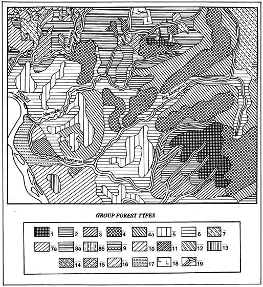
Figure 1. Forest vegetation in the south - eastern part of the Angara-Yenissei region (to the fragment of the map of scale 1:200 000).
I. Middle high mountain zone with mountain forest and taiga (500-600 meters): 1- pine-Siberian pine-larch, larch whortleberry-herbaceous, whortleberry lichen on turf, low podzol loamy and sandy soils of high hills’ tops and chines (climactic);
II. Low mountains and pediment (400-500 meters): 2-siberian pine, fir-Siberian pine, whortleberry-green moss, green moss on constructional, loamy soils of high narrow chines and steep slopes, (climactic), 3a- pine-Siberian pine, Siberian pine-larch herbaceous-sledge on disturbed Siberian pine, fir-Siberian pine whortleberry-green moss watersheds and high chines (secondary), 4- Siberian pine-fir with pine, larch small herbaceous-green moss on denuded sediments of traps of Preangarian low mountain zone and plateau, (climactic), 4 a- fir-Siberian pine-birch, birch-fir-Siberian pine, herbaceous-green moss forests in disturbed Siberian pine-fir forests with pine, larch, herbaceous-shrub-green moss forests of the Preangarian low mountain zone and plateau (secondary), 5- larch-pine, Siberian pine-pine, pine whortleberry-lichen, whortleberry-bearberry forests of low mountain chines and elevated plateaus, (climactic), 6- birch-pine, fir-birch-pine, whortleberry-sledge steep slopes, (climactic), 7 -fir-Siberian pine-spruce, Siberian pine-spruce sledge-herbaceous forests on gentle slopes (chiefly of the northern exposition) of mountain ridges and watersheds,(climactic), 7 a - Siberian pine-spruce-birch, Spruce- Siberian pine herbaceous-sledge on the sites of disturbed fir-Siberian pine-spruce, Siberian pine-spruce sledge-herbaceous forests on gentle slopes and watersheds (secondary);
III. Prominent and flat divide plains (250-400 meters): 8 a- fir-birch, spruce -fir-birch, birch with spruce, herbaceous-green moss forests of flat plains on the sites of disturbed climactic fir forests (secondary), 8 b- spruce-fir-asp, Siberian pine-fir-asp whortleberry-herbaceous, herbaceous-sledge on the sites of disturbed fir forests (secondary);
IV. Taiga region of river plains, terraces and slope-valley complexes: 9- birch-pine, pine herbaceous-fern, herbaceous of the lower parts of slopes, ravines, 10- birch-pine, pine with spruce, sledge-herbaceous of lower terraces, 11- Siberian pine-spruce, spruce-long moss, wild rosemary-sphagnum in flood-lands of rivers and brooks, 12- spruce-Siberian pine, wild rosemary-sphagnum of lower terraces, 13- pine, pine with birch, wild rosemary-sphagnum of lower terraces and flood-lands of rivers, 14- pine with birch, sphagnum of terraces’ depressions and wet flood-lands of rivers;
V. Under anthropogenic influence transformed zones: 15-reinstating clearings, 16- saplings on clearings, 17- meadows, 18- not- reinstating clearings, 19-rivers.
4. Conclusion
Study of the structure of forest cover and its dynamics while mapping forest vegetation in the south-eastern part of the Angara-Yenisei region has shown that before making the mathematical models to forecast carbon circulation in the main types of boreal forest ob site data on complex spatial-temporal cycles should be obtained. These cycles should reflect the process of formation of the most representative geosystems that are "nuclei" for landscape units of different altitude level.
We give the characteristic of the up-to-date state forest vegetation in the south-eastern part of the Angara-Yenisey region. One of the promising methods of fulfilling a given task in order of the main types of boreal forests in mid-Siberia is to research the forest communities and to type them on the landscape basis. For this purpose we used the classical notions about the invariant of the geosystems and about the genetic type of a forest.
To prove them we give as an example a computer-made map.To prepare the computer-made map of forest vegetation in the south-eastern part of the Angara-Yenisey region we used a multifunctional adaptable geo-information МАGIS-32 system, designed by the Siberian scientific–publishing and manufacturing centre of geo-information and applied geodesy.
Analysis of the map of forest vegetation in the south-eastern part of the Angara-Yenisey region shows that each altitude level has its own climactic forest type that is a "nucleus" for this particular belt of forest vegetation.
The fragments of the maps (Fig. 1) make it clear that the structure of forest cover is formed under the influence of the vertically organised altitude belts and has four levels from the mountain-taiga, mainly larch, pine - larch, larch - pine forests in the belt 500-600 meters above sea level, to the low mountain foothill fir – Siberian-pine and Siberian-pine - fir forests on traps in the belt 400-500 meters above sea level.
Comparison of a fragment of the forest vegetation map with of a fragment of the map (image 1953) shows that over the last 40 years the area of birch-aspen forests has increased to cover 45-60 % by comparison with 1953 when it covered only 15-20 %. Considerable anthropogenic impact is characteristic of other parts of the areas studied.
Accordingly, for the middle mountain belt (500-600 meters above sea level) the "carbon" model must be considered using the example of an ecosystem of the larch whortleberry-lichen, whortleberry-herbaceous forest type, and for convex watershed plains (250-400 meters above sea level) using the example of the Siberian-pine – spruce – fir, green-moss forest.
As a result of disturbance of natural cycles of regeneration of fir communities and in some cases of pine communities, the structure of the redistribution of forest vegetation changes over space, and consequently the character of the carbon accumulation in forest ecosystems changes.
Adaptation of models of carbon circulation to a regional level will require a clear-cut mapping that will give an idea not only of the present state of forest vegetation, but also of the spatial-temporal dynamics of forest types, their age structure and area correlation between different types of communities.
References
- Belov, A.V., Lyamkin, V.F., and Sokolova, L.P.: 2002. Cartographic study of the biota. Publishing House", Irkutsk pp. 1-160.
- Dyrenkov, S.A.: 1985. On the differing objectives and experience of phytocenological and Biogeocenological classifications. In A classification of the USSR vegetation. Izdatelstvo Moskovskogo universiteta, Moscow pp. 10-20.
- Kalashnikov, E.N.: 1987. Invetsigation of forest landscapes by remote-sensing methods (a case study of the Angara-Yenisei region). In Investigation of forests by aerospace methods. Nauka Publishing House of the Siberian Division RAS, Novosibirsk pp. 10-31.
- Kolesnikov, B.P.: 1958. Status of Soviet forest typology, and the problem of genetic classification of forest types. Izv. SO RAN SSSR 2: 109-122.
- Krauklis, A.A.: 1979. Problems of experimental landscape science. Nauka Publishing House of the Siberian Division RAS, Novosibirsk pp. 1-233.
- Kuzmenko, E.I.: 2001a. Comparative characterisation of the structure and dynamics of Siberian stone pine forests in the southern-taiga subzone of the Angara-Yenisei region. In Proc. Intern. Forum on the Problems of Science, Technology and Education. Publishing House of the Academy of Earth Sciences. Moscow pp. 43-47.
- Kuzmenko, E.I.: 2001b. Up-to-date state and transformation of the south-taiga subzone forests of the right side of Yenisei region. Their biosphere role. ESRI Library, U.S. New York,http://campus. esri. com/campus. library/ Bibliography/ RecordDetail. Ccfm? ID=13343.
- Kuzmenko, E.I., and Smologonov, E.P.: 2000a. Forest ecosystems of the middle and southern taiga of the West-Siberian plain (structure and spatial-temporal dynamics). Publishing House of the Siberian Branch RAS, Novosibirsk pp. 1-218.
- Kuzmenko, E.I., and Smologonov, E.P.: 2000b. Toward a characterisation of the present state and transformation of the southern-taiga forests of the Angara-Yenisei region (right riverside of the Yenisei). In Proc. Intern. Formun on the Problems of Science, Technology and Education. Publishing House of the Academy of Earth Sciences. Moscow pp. 31-33.
- Kuzmenko, E.I., and Smologonov, E.P.: 2002a. Up-to-date state and transformation of the south taiga subzone forests, in Track, 22 Annual ESRI International User Conference. Section Forestry, Wildlife and Fisheries Management. San-Diego, U.S., CD.
- Kuzmenko, E.I., and Smologonov, E.P.: 2002b, Up-to-date state and transformation of forests in the southern-taiga subzone of the right riverside of the Yenisei: their biospheric role. Zh. Geogr. i prirod, resursy 3: 68-76.
- Kuzmenko, E.I., and Ulybina, L.O.: 2002. Forest vegetation of the south-eastern part of the Angara-Yenisei region (right riverside of the Yenisei). Map. Publishing House Sibgeoform, Novosibirsk: 1:200000 (in electronic form).
- Kuzmenko, E.I., Mikheev, V.S. (2008) The Ecologo-Geographical and Cartographic Foundations of a Comprehensive Study of Siberia's Forests. Academic Publishing House "Geo", Novosibirsk.
- Mikheyev, V.S.: 1987. Landscape-geographical support of the integrated problems of Siberia. Nauka Publishing House of the Siberian Division RAS, Novosibirsk pp. 1-207.
- Smologonov, E.P.: 1990. Ecological-geographical differentiation and dynamics of Siberian stone pine forests of the Urals and West-Siberian plain, Sverdlovsk pp. 1-236.
- Smologonov, E.P., and Zalesov, S.V.: 2002. The ecological-silvicultural foundations of the organisation and management of the economy in Siberian stone pine forests of the Urals and West-Siberian plain. Yekaterinburg pp. 1-182.
- Sochava, V.B.: 1978. Introduction to the concept of geosystems. Nauka Publishing House of the Siberian Division RAS. Novosibirsk pp. 1-190.
- Suvorov, E.G.: 1980. An investigation into the man-made changes of the geosystems of the Chuna region landscapes. In The study of the states of geosystems. Irkutsk pp. 26-36.
- Vaganov, E.A., Shiyatov, S.G., and Mazepa, V.S.: 1996. Dendroclimatic investigations in the Ural-Siberian Subarctic. Publishing Company SB RAS, Novosibirsk, pp. 1-243.
- Vlasenko, V.I., Ovchinnikova, T.M., and Panyushkina, I.P.: 1999. The dynamics of the Eastern Sayan forests (a case study of the "Stolby" preserve). Botanicheskie issledovaniya v Sibiri 7: 23-72.
- Multifunctional adaptable geo-information system (MAGIS32) (User’s manual). 2000. Novosibirsk.


