
American Journal of Mobile Systems, Applications and Services, Vol. 1, No. 1, August 2015 Publish Date: Jul. 23, 2015 Pages: 46-53
Modeling Land Mobile Satellite Channel and Mitigation of Signal Fading
Oluyomi Aboderin1, *, Isiaka A. Alimi2
1Department of Engineering and Space Systems, National Space Research and Development Agency (NASRDA), Abuja, Nigeria
2Department of Electrical and Electronics Engineering, School of Engineering and Engineering Technology, Federal University of Technology, Akure, Nigeria
Abstract
Land mobile satellite (LMS) is an important aspect of satellite communication to everyone across the globe due to the services available through it. To this effect, modeling the channel in this services is also very important, so as to ensure availability, quality of service (QoS), and reduce outages on the channel, which in turn will results into value for money, safety of lives and properties, and even reduce cost both from the operator’s point of view and user’s point of view. In this work, a Lutz two-state statistical model was used to model the behavior of a complete channel in two different transmission environments namely: shadowing and un-shadowing or line-of-sight (LOS) and non-line-sight (NLOS) conditions. However due to the influence of the propagation environment on the LMS signals, there were outages (fading) along the 200meters length of the measurement campaign. To reduce these outages, satellite diversity technique was employed. This technique pair together two satellites having the same masking angle and both simultaneously linked with the mobile terminal. The results show that connectivity to the two satellites improved the satellites availability to the mobile terminal up to 90%, and the service quality also was improved.
Keywords
Land Mobile Satellite (LMS), Channel, Lutz Two-State Statistical Model, Shadowing, Unshadowing, Line-of-Sight (LOS), Non-Line-of-Sight (NLOS), Mobile Terminal
Received: June 12, 2015
Accepted: July 3, 2015
Published online: July 22, 2015
@ 2015 The Authors. Published by American Institute of Science. This Open Access article is under the CC BY-NC license. http://creativecommons.org/licenses/by-nc/4.0/
1. Introduction
In today’s growing world of modern technology, satellite communication has taken a driver seat as one of the most reliable source of communication in almost every part of the World. The usefulness of satellite communication covers a great while in the communication systems. Apart from providing communication across a geographically separated great distances, giving opportunity for life transmission and reception of programs (Sport competition) or life-monitoring of events, it has also been a source of reaching areas ravaged by natural disasters (Earthquake, Tsunami, deadly erosions) and even war ravaged areas, as well as weather forecast, which is very important for travelers either through aviation, maritime and road transportation industries. Land Mobile Satellite (LMS) communications gives the seamless communication between a satellite in space and a number of mobile remote terminals, or mobile devices on the earth surface. Channel on the other hand is the space between a transmitter and a receiver. It is needful to say that LMS channel possess the properties of the mobile and satellite channel which include multipath effect, Doppler shift and fading. The important part of modeling LMS channel is to ensure better QoS which in turn will ensure proper communication most especially when there is urgent need to use services in this respect for life saving. This work does present brief introduction to satellite channel impairments, two-state Markov chain with its analysis, presenting means of reducing outages through satellite diversity techniques and rounding up with the conclusion.
2. Land Mobile Satellite Channel Impairments
In radio waves communications, transmission environment play a significant role in the communication between a Mobile Terminal (MT) or Mobile Earth Station (MES) (the two will be used interchangeably throughout this work) and artificial satellites in space. The received LOS signal is typically affected by diffuse scatter from objects near MES, specular reflection both from the ground and near the user at any elevation angle, and also from the inclined smooth terrain in the direction of the satellite at low elevation angle [1-3]. Propagation of LMS signals is often affected by; the ionospheric effect, the tropospheric effect and the propagation environment surrounding the mobile terminal. But at the L-band and S-band frequencies being used for LMS, tropospheric effect is negligible, while circular polarization can be used to counter effect of Faraday rotation that is caused by ionospheric effect. This leaves propagation environment as the only impairment that affects LMS channel [4, 5]. Effective communication through land mobile satellite links requires real understanding of the impairments that can affect signal transmission, which might be due to blockage of line-of- sight (LOS) path, multipath effect and even the transmission environments where the mobile terminal is located. Figure 1 shows the components of LMS network and the propagation environment.
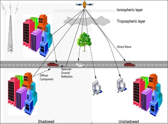
Fig. 1. LMS network propagation environment.
Indeed, the signal received by a satellite mobile terminal can be divided into three components namely:
1) The direct line-of-sight (LOS) wave: it is otherwise referred to as direct wave in figure 1, it is the signal received by a MT or MES without any form of seen obstruction; it can as well be referred to as unshadowed waves [6].
2) The diffuse wave: the diffuse component is made up of several signals that arrived at the mobile terminal at different time and phases known as multipath. This is purely local effects, which can interact with radio wave being received by mobile terminal, it include buildings, vehicles, and other structures.
3) Specular ground reflected wave: this is a phase coherent reflected wave and it can result into deep fading of the received signal, if it has relative amplitude to that of the direct component. Mobile terminals that is operating at low elevation angle to the satellite and also has antenna with low gain, and wide beam-width could be easily affect by this impairment.
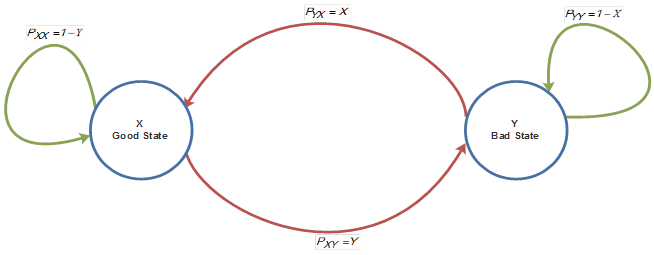
There is a logical relationship between signal received by a MT or MES, and the transmission environment where it is located, because percentage of shadowing depends largely on the type of transmission environments as well as the elevation angle of the user’s equipment and the Doppler shift as the MT changes location. Thus, two states Markov chain reflected shadowed and unshadowed conditions representing availability or non-availability of the satellite to mobile terminal at different transmission or propagation environment. The former described as BAD state or NLOS that is when the link is obstructed by any obstacles, while the later described GOOD state or LOS. Based on this analysis, Markov chain was used to model the scenario of both states earlier mentioned as shown in Figure 2.
For a mobile user that is moving with speed v, the mean extent measured in meters of shadowed and unshadowed areas,![]() and
and ![]() , and this translate into mean time interval
, and this translate into mean time interval![]() and
and ![]() , where the channel stays in the good and bad state respectively [5, 7]. The finite state Markov model will either represent the state models as seen in Figure 2 or the two different transmission environments namely shadowed and un-shadowed conditions [1]. The overall probability density function (pdf) for the combination of the good state Rician distribution and bad state Rayleigh distribution is given by:
, where the channel stays in the good and bad state respectively [5, 7]. The finite state Markov model will either represent the state models as seen in Figure 2 or the two different transmission environments namely shadowed and un-shadowed conditions [1]. The overall probability density function (pdf) for the combination of the good state Rician distribution and bad state Rayleigh distribution is given by:
![]() (1)
(1)
Where ![]() is the probability that MT remains in the good state and
is the probability that MT remains in the good state and ![]() is the probability for it remains in the bad state,
is the probability for it remains in the bad state, ![]() and
and ![]() are the respective pdf for the signal variations of the GOOD and BAD states respectively. It is a narrowband model as the time-spreading effects are not taking into consideration. The following assumptions were made with respect to this model:
are the respective pdf for the signal variations of the GOOD and BAD states respectively. It is a narrowband model as the time-spreading effects are not taking into consideration. The following assumptions were made with respect to this model:
Ÿ State transitions were modeled based on first-order, discrete-time Markov chain.
Ÿ The variation of signals within each state can mainly be described by several possible distributions like Rayleigh, Loo, Suzuki, Corazza and Rician. In this paper Raleigh and Rician were used for the two states [7, 12, 13].
The transmission rate R, the mean state durations normalized to symbol duration with transition probabilities ![]() and
and![]() yields [9, 14]:
yields [9, 14]:
![]() (2)
(2)
![]() (3)
(3)
where ![]() is the probability of transition from good state to bad state and
is the probability of transition from good state to bad state and![]() is the probability of transition from bad state to good state. But from the relations
is the probability of transition from bad state to good state. But from the relations
![]() (4)
(4)
![]() (5)
(5)
And ![]() is the probability that the mobile user moves from bad state to bad state or simply remains in the bad state, which is attributed to non-line-of-sight, conversely
is the probability that the mobile user moves from bad state to bad state or simply remains in the bad state, which is attributed to non-line-of-sight, conversely ![]() is the probability that the mobile user moves from good state to good state or simply remains in the good state also attributed to availability of service scenario. Equilibrium state probabilities are derived as:
is the probability that the mobile user moves from good state to good state or simply remains in the good state also attributed to availability of service scenario. Equilibrium state probabilities are derived as:
![]() (6)
(6)
![]() (7)
(7)
where probability![]() corresponds to the time share during shadowing and
corresponds to the time share during shadowing and![]() corresponds to unavailability of service scenario, definitely
corresponds to unavailability of service scenario, definitely ![]() and
and ![]() are for the time share during un-shadowing and availability of service respectively [7].
are for the time share during un-shadowing and availability of service respectively [7].
For modeling the scenario of two-state Markov chain of bad and good state, the parameters for each state, the entire state, and the transition matrices for different environment and elevation angle are calculated based on the measurements conducted. Thus, absolute state and the transition probability matrices, W and P have been used to model the state occurrences and durations. With
![]() (8)
(8)
where elements of state probability,![]() fulfill equation. Also, elements of transition probability matrix is fulfill [15]
fulfill equation. Also, elements of transition probability matrix is fulfill [15]
![]() (9)
(9)
where Pi|j is the probability of transition from state j to state i, and the convergence property of Markov chain is given by [4]:
![]() (10)
(10)
With [W] equals absolute probability matrix and [P] equals transition probability matrix [4, 16]. Having defined the Markov one of the parameters needed for the model, it is also necessary to define minimum state duration or frame (discrete-time Markov chain), LFrame is 1m. Note that "duration" can both be used for length of distance travelled (in meters) and time duration (in second), the two were related by the terminal speed, V, which is assumed constant all through the measurement campaign. The state duration depends on the transition probabilities ![]() and the probability that the Markov chain stays in a given state, i, for n consecutive frames or equivalently for
and the probability that the Markov chain stays in a given state, i, for n consecutive frames or equivalently for ![]() meters (or
meters (or![]() ) is given by [4, 15];
) is given by [4, 15];
![]() (11)
(11)
And the cumulative distribution for each state’s duration is given as:
![]() (12)
(12)
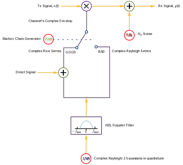
Random number generator is used to get an update of the current state, which is made by drawing random number of each Lmetres. The variations within GOOD state are modeled by means of Rician distribution and Rayleigh distribution is used for modeling the BAD state. Butterworth filter was used to introduce autocorrelation of these fast variations and the block diagram that was used for modeling the entire channel scenario is the combination of two-state Markov chain and Lutz’s Rayleigh/Rice LMS channel simulator, which has a time-series generator. This is as shown in Figure 3.
With carrier frequency set to 1593 MHz which is the center frequency for a named satellite service operating in the L-Band, frame length set at 1m, for wavelength at this frequency, the sampling fraction of the wavelength used was 6. The standard deviation for the GOOD state and BAD state were set at 0.2 and 0.15 respectively. When using ![]() for the Gaussian generators with quadrature, the results are
for the Gaussian generators with quadrature, the results are ![]() and
and ![]() respectively. The parameters of the Butterworth filter used for Doppler shaping are
respectively. The parameters of the Butterworth filter used for Doppler shaping are ![]()
![]()
![]() . By varying this transmission matrix in line with the transmission environments plots that give the behavior of a complete channel is generated and in this scenario transmission matrix
. By varying this transmission matrix in line with the transmission environments plots that give the behavior of a complete channel is generated and in this scenario transmission matrix![]() was used. Then using these parameters, the channel response in linear and logarithmic form were generated with the state series showing the transiting between good and bad state as the mobile devices travelling along the 200 meters length. The plots of state series, multipath characteristics, filter response and the entire channel responses in linear and logarithmic forms were shown in Figures; 4, 5, 6, 7 and 8.
was used. Then using these parameters, the channel response in linear and logarithmic form were generated with the state series showing the transiting between good and bad state as the mobile devices travelling along the 200 meters length. The plots of state series, multipath characteristics, filter response and the entire channel responses in linear and logarithmic forms were shown in Figures; 4, 5, 6, 7 and 8.
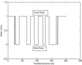
Fig. 4. State series for the channel characteristics.
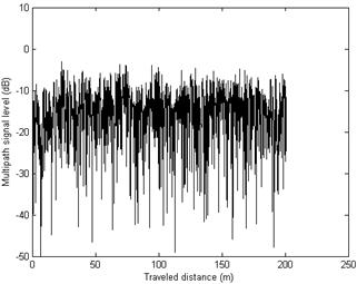
Fig. 5. Multipath Characteristics of the Channel.
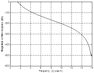
Fig. 6. Filter response of the Channel.
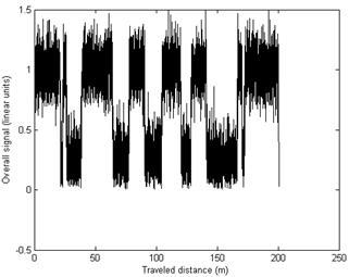
Fig. 7. Channel response in linear form for the distributions.
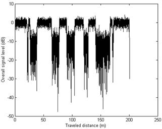
Fig. 8. Channel response in logarithmic form for the distributions.
4. Satellite Diversity Technique
Based on these plots, it was discovered that of the 200 m length of the journey, the satellite availability is limited to 127m, which represent about 60% of the journey. This simply means for the remaining 40%, there were outages on the channel. This can be very costly in terms of service quality. Thus, satellite diversity technique was implemented to combat the outages experienced in the channel this is done by ensuring a proper Inter-Satellite-Link between two Geo Stationary Earth orbiting (GEO) satellites at -42.50E and 150W. Since each of the satellites has more than 50% probability of availability to the mobile terminals, then the probability of availability of the two satellites increased to above 90% of the total length of the journey [11]. This will have no effect on the round trip time delay (latency) of 250ms, as each of the satellites share the satellite resources. Figure 9 shows the use of two satellites to achieve availability to a mobile terminal.
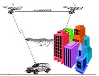
Fig. 9. Satellite diversity techniques through two satellites.
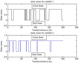
Fig. 10. State Series responses during Satellite diversity.
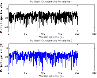
Fig. 11. Multipath Characteristics of the two Satellites.
The probability of satellite being invisible to a MT or MES is the product of the probabilities of the satellite invisibility due to each of individual satellite which eventually reduces their entire probability [1]. It can thus be said that satellite diversity can actually reduce link power margin and improve the service availability (the percentage at which is available) for a mobile terminal. In the case of land mobile satellite link, the two satellites communicate with a mobile terminal simultaneously. This can be used in GEO and Non-Geo Stationary Earth Orbiting (NGEO) satellites. The results of using two satellites are as shown in Figures 10 to 14. Stating their combined; state series, multipath effect, channel filter response, as well as the entire channel response both in the linear and logarithmic forms. For NGEO satellite, it is a complicated technique which involves satellite handover, masking angle of satellite, which is the angle at which the satellite begins to appear to the mobile terminal. Two or more satellites can be used here, with satellite link enters available state if at least one of the satellites is visible to a MT or MES, otherwise it will be unavailable state. In GEO, it is somewhat different as two satellite links is used to provide availability to a MT or MES, such that if one is shadowed, the other will be available, thereby providing the required access. It is less complicated, there is no handover, and their angle of elevation to the MT or MES is relatively correlated to each other.
Looking into the overall channel response shown in Figures 13 and 14, it can be said that with the use of two satellites, the availability to the users have been tremendously improved to above 90% as previously mentioned.
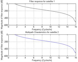
Fig. 12. Filter responses of the two Satellites.
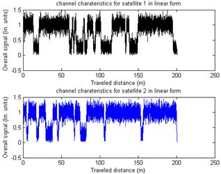
Fig. 13. Overall channel characteristics through the satellites in linear form.
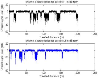
Fig. 14. Overall channel characteristics through the satellites in logarithmic form.
5. Conclusion
In this work two-state Markov chain has been used to model the scenario observed when a mobile terminal is transiting within two different propagation environments. The propagation environments determine the connectivity of the mobile to the satellite or simply availability of the satellite to the mobile user. This has been demonstrated that with single satellite, the probability of outages on the channel is nearly 50% which will definitely reduce the Quality of Service (QoS) expected by the mobile terminal. But it was also demonstrated that satellite diversity technique where the mobile terminal simultaneously has connectivity to two satellites can be used to combat the fading and reduce the outages to less than 10%. It is believed that using multiple satellites connectivity at lower orbits will ensure that mobile terminal will have a seemingly 100% connectivity to the satellite, but this network will require to have a lot of handing over which will make the network to be very cumbersome.
References
- R. E. Sheriff and Y. F. Hu, Mobile Satellite Communication Networks, First Edition ed. Chichester: John Wiley & Sons, Ltd., 2001.
- W. J. Vogel, "Satellite Diversity for Personal Satellite Communications - Modelling and Measurements," presented at the 10th International Conference on Antennas and Propagation, London, 1997.
- M. Rieche, A. Ihlow, D. Arndt, F. Perez-Fontan, and G. Del Galdo, "Modeling of the Land Mobile Satellite Channel considering the Terminal's Driving Direction," International Journal of Antennas and Propagation, 2015 2015.
- F. P. Fontan and P. M. Espineira, Modeling the Wireless Propagation Channel A Simulation Approach with MATLAB, 229 ed. Chichester: Wiley and Sons Ltd, 2008.
- S. R. Saunders and A. A. Zavala, Antennas and propagation for Wireless Communication Systems, Second Edition ed. Chichester: John Wiley & Sons Ltd., 2007.
- L. J. Ippolito, Satellite Communications Systems Engineering: Atmospheric Effects, Satellite Link Design and System Performance. Chichester: John Wiley & Sons Ltd, 2008.
- E. Lutz, "A Markov model for correlated land mobile satellite channels," International Journal of Satellite Communications, vol. 14, pp. 333-339, 1996.
- E. Lutz, M. Werner, and A. Jahn, Satellite Systems for Personal and Broadband Communications, 1st ed. Berlin: Springer, 2000.
- H. Bischl, M. Werner, and E. Lutz, "Elevation-dependent channel model and satellite diversity for NGSO S-PCNs," 1996 Ieee 46th Vehicular Technology Conference, Proceedings, Vols 1-3, pp. 1038-1042, 1996.
- S. Scalise, H. Ernst, and G. Harles, "Measurement and Modelling of the Land Mobile Satellite Channel at Ku band," IEEE Transaction on Vehicular technology, vol. 57, p. 11, 2008.
- E. Lutz and Ieee, "Modelling of the Satellite Communications Channel - With Emphasis on the Land Mobile Satellite Channel," 2012 Ieee First Aess European Conference on Satellite Telecommunications (Estel), 2012 2012.
- M. Z. H. Bhuiyan, J. Zhang, E. S. Lohan, W. Wang, and S. Sand, "Analysis of Multipath Mitigation Techniques with Land Mobile Satellite Channel Model," Radioengineering, vol. 21, Dec 2012.
- M. Cheffena, F. Perez Fontan, F. Lacoste, E. Corbel, H.-J. Mametsa, and G. Carrie, "Land Mobile Satellite Dual Polarized MIMO Channel Along Roadside Trees: Modeling and Performance Evaluation," Ieee Transactions on Antennas and Propagation, vol. 60, pp. 597-605, Feb 2012.
- E. Lutz, "Issues in satellite personal communication systems," Wireless Networks, vol. 4, pp. 109-124, 1998.
- M. C. Jeruchim, P. Balaban, and S. K.S, Simulation of Communication Systems Modelling, Methodology and Techniques, Second Edition ed. New York, 2000.
- F. P. Fontan, S. Martinez, B. Sanmartin, C. Enjamio, P. Marino, and F. Machado, "An enhanced Markov chain based model for the narrowband LMS channel in built-up areas," International Journal of Satellite Communications and Networking, vol. 23, pp. 111-128, 2005.
- E. Lutz, D. Cygan, M. Dippold, F. Dolainsky, and W. Papke, "The land mobile satellite communication channel-recording, statistics, and channel model," Ieee Transactions on Vehicular Technology, vol. 40, pp. 375-386, 1991.


